Near Charles City in Charles City County, Virginia — The American South (Mid-Atlantic)
Chickahominy Water Trail
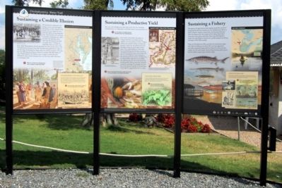
(left panel)
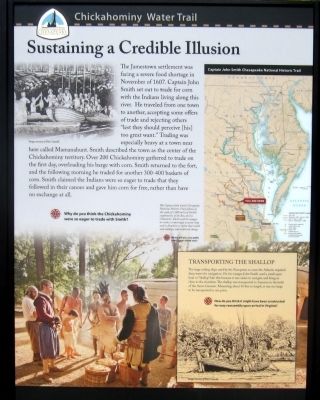
Sustaining a Credible Illusion
The Jamestown settlement was facing a severe food shortage in November of 1607. Captain John Smith set out to trade for corn with the Indians living along this river. He traveled from one town to another, accepting some offers of trade and rejecting others “lest they should perceive [his] too great want.” Trading was especially heavy at a town near here called Mamanahunt. Smith described the town as the center of Chickahominy territory. Over 200 Chickahominy gathered to trade on the first day, overloading his barge with corn. Smith returned to the fort, and the following morning he traded for another 300-400 baskets of corn. Smith claimed the Indians were so eatger to trade that they followed in their canoes and gave him corn for free, rather than have no exchange at all.
Why do you think the Chickahominy were so eager to trade with Smith?
(sidebar)
Transporting the Shallop
The large sailing ships used by the Europeans to cross the Atlantic required deep water for navigation. On his voyages John Smith used a small open boat or “shallop” like this because it was easier to navigate and bring in close to the shoreline. The shallop was transported to America in the hold of the Susan Constant. Measuring about 30 feet in length, it was too large to be transported in one piece.
How do you think it might have been constructed for easy reassembly upon arrival in Virginia?
(center panel)
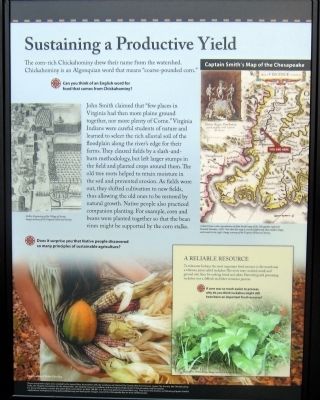
Sustaining a Productive Yield
The corn-rich Chickahominy drew their name from the watershed. Chickahominy is an Algonquian word that means “coarse-pounded corn.”
Can you think of an English word for food that comes from Chickahominy?
John Smith claimed that “few places in Virginia had then more plaine ground together, nor more plenty of Corne.” Virginia Indians were careful students of nature and learned to select the rich alluvial soil of the floodplain along the river’s edge for their farms. They cleared fields by a slash-and-burn methodology, but left larger stumps in the field and planted crops around them. The old tree roots helped to retain moisture in the soil and prevented erosion. As fields wore out, they shifted cultivation to new fields, thus allowing the old ones to be restored by natural growth. Native people also practiced companion planting. For example, corn and beans were planted together so that the bean vines might be supported by the corn stalks.
Does it surprise you that Native people discovered so many principles of sustainable agriculture?
(sidebar)
A Reliable Resource
To Tidewater Indians the most important food resource in the marsh was a tuberous plant called Tuckahoe. The roots were crushed, cured, and ground into flour for making bread and cakes. Harvesting and processing Tuckahoe was a difficult and labor-intensive process.
If corn was so much easier to process, why do you think tuckahoe might still have been an important food resource?
(right panel)
Sustaining a Fishery
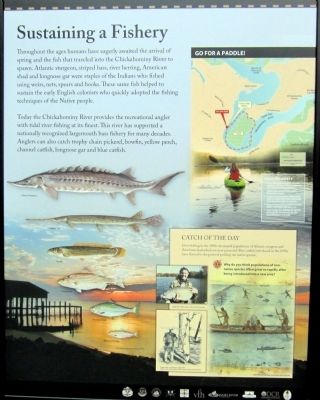
Throughout the ages humans have eagerly awaited the arrival of spring and the fish that traveled into the Chickahominy River to spawn. Atlantic sturgeon, striped bass, river herring, American shad and longnose gar were staples of the Indians who fished using weirs, nets, spears and hooks. These same fish helped to sustain the early English colonists who quickIy adopted the fishing techniques of the Native people.
Today the Chickahominy River provides the recreational angler with tidal river fishing at its finest. This river has supported a nationally recognized largemouth bass fishery for many decades. Anglers can also catch trophy chain pickerel, bowfin, yellow perch, channel catfish, longnose gar and blue catfish.
(sidebar)
Catch of the Day
Over-fishing in the 1900s decimated populations of Atlantic sturgeon and American shad which are now protected. Blue catfish introduced in the 1970s have thrived to the point of pushing out native species.
Why do you think populations of non-native species often grow so rapidly after being introduced into a new area?
These interpretive signs were created by the James River Association with the assistance of Charles City County, New Kent County, James City County, the Chickahominy Tribe, the Virginia Foundation for the Humanities, the Virginia Council on Indians, and the Virginia Department of Conservation and Recreation.
For more information contact the James River Association at (804) 788-8811 or visit www.jamesriverassociation.org. Find more information on following Captain Smith’s exploration of Virginia at www.johnsmithtrail.org and tracing his voyages around the Chesapeake Bay at www.smithtrail.net.
Erected by James River Association.
Topics and series. This historical marker is listed in these topic lists: Exploration • Native Americans • Settlements & Settlers • Waterways & Vessels. In addition, it is included in the Captain John Smith Chesapeake National Historic Trail series list. A significant historical month for this entry is November 1607.
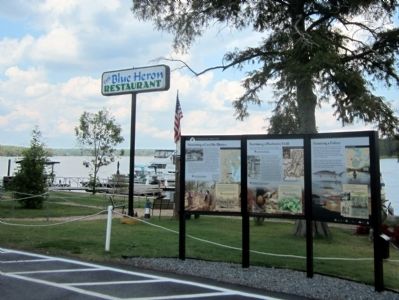
Location. 37° 21.783′ N, 76° 54.757′ W. Marker is near Charles City, Virginia, in Charles City County. Marker can be reached from Wilcox Neck Road (Virginia Route 623) half a mile north of The Glebe Lane (Virginia Route 615). Located in the Blue Heron Restaurant parking lot at Rivers Rest Marina. Touch for map. Marker is at or near this postal address: 9100 Wilcox Neck Road, Charles City VA 23030, United States of America. Touch for directions.
Other nearby markers. At least 8 other markers are within 5 miles of this marker, measured as the crow flies. Holdcroft (approx. 1.2 miles away); Mt. Zion & Rustic (approx. 2.6 miles away); a different marker also named Chickahominy Water Trail (approx. 3.3 miles away); Piney Grove (approx. 3.7 miles away); Piney Grove and Southalls (approx. 3.7 miles away); Fort James (approx. 4.1 miles away); Binns Hall (approx. 4.2 miles away); Diascund Bridge (approx. 4.3 miles away). Touch for a list and map of all markers in Charles City.
More about this marker. (left panel)
On the upper left is a sketch of the traders. Image courtesy Marc Castelli. On the upper right is a map of the Captain John Smith Chesapeake National Historic Trail with the caption “The Captain John Smith Chesapeake National Historic Trail follows in the wake of 3,000 miles of Smith’s exploration of the Bay and its tributaries. Smith used his voyages to create a surprisingly accurate map and to document a region that would soon undergo unprecedented change, Where will you cross paths with Captain Smith next?” National Geographic On the lower left is a reenactment of the traders. Image courtesy Robert Llewellyn. On the lower right is a drawing of a shallop. Image courtesy Marc Castelli.
(center panel)
On the upper left is a "DeBry engraving of the Village of Secota." Image courtesy of the Virginia Historical Society. On the upper right a Captain John Smith’s Map of Chesapeake with the caption, "A detail from a color reproduction of John Smith’s map of the Chesapeake region by Hendrik Hondius, 1630. Note this map is oriented differently than modern maps, with north to the right." Image courtesy of the Virginia Historical Society.On the lower left is a photo of a native harvest. Image courtesy Robert Llewellyn. On the lower right is a photo of "Tuckahoe or Arrow Arum." Image courtesy of Irvine Wilson.
(right panel)
On the left are images of "Atlantic Sturgeon; Longnose Gar; Bowfin; Striped Bass; American Shad; Blueback Herring". On the upper right is a map entitled "Go For a Paddle!" with safety tips. On the lower right are photos of anglers and their trophies as well as an illustration of native fishing techniques.
Also see . . .
1. James River Association. (Submitted on August 25, 2011, by Bernard Fisher of Richmond, Virginia.)
2. Captain John Smith’s Trail. (Submitted on August 25, 2011, by Bernard Fisher of Richmond, Virginia.)
3. Captain John Smith Chesapeake National Historic Trail. (Submitted on August 25, 2011, by Bernard Fisher of Richmond, Virginia.)
Credits. This page was last revised on June 16, 2016. It was originally submitted on August 25, 2011, by Bernard Fisher of Richmond, Virginia. This page has been viewed 797 times since then and 16 times this year. Photos: 1, 2, 3, 4, 5. submitted on August 25, 2011, by Bernard Fisher of Richmond, Virginia.
