Lariat Loop Byway: Denver Mountain Parks
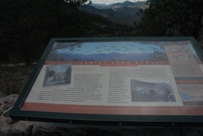
•These foothills west of Denver have long been a popular destination. In 1890 landscape architect Frederic Law Olmsted, who designed New York’s Central Park, was hired by local developers to design a resort in this area. Three years later the project was canceled due to financial problems. In 1911, a group of Denver citizens began planning a system of parks in the foothills. The idea of a city maintaining a parks system more than 12 miles outside of its limits was unprecedented. But these visionaries saw such a system as an automobile touring destination, serving the people of Denver as well as attracting millions of tourist dollars to the area. Twenty years after the first development effort by Olmsted, his son Frederick Law Olmsted, Jr. was hired to design the system.
•In 1912 Denver voters approved a plan to establish the Denver Mountain Parks system. A year later Lookout Mountain Park, where you now stand, and the Lariat Loop road, which you see below you, were created. Shortly after that, Buffalo Bill visited the Park and asked to be buried here. Over the years the Denver Mountain parks system grew until today it includes 14,000 acres in 46 park parcels located in three counties in the front-range Denver metropolitan area. Among the better known parks in the system are Red Rocks (site of the
world-renowned amphitheatre), Genesee (home of a city-owned buffalo herd since 1914), and Echo Lake (at the base of Mount Evans). All are maintained by the City of Denver Parks and Recreation Department.•The Lariat Loop connects the communities of Morrison, Golden, Evergreen, Lookout Mountain, and Genesee, with many memorable stopping places along the way, from dinosaurs to Buffalo Bill to rock stands. You have discovered on of the most scenic and historic drives in the West. Enjoy your visit!
•Along the way, look for:
•Great museums and galleries.
•Parks, trails, and wildlife.
•Scenic vistas and special places.
•Shops, lodging, and restaurants.
•Historic signs of early settlers.
•Follow the Lariat Loop signs and pick up a brochure along the way for more great sites to explore.
Topics. This historical marker is listed in this topic list: Landmarks. A significant historical year for this entry is 1890.
Location. 39° 43.985′ N, 105° 14.319′ W. Marker is near Golden, Colorado, in Jefferson County. It is in Lakota Hills. Marker is on Lariat Loop Byway. Marker is located at parking lot to the Buffalo Bill Museum. Touch for map. Marker is in this post office area: Golden CO 80401, United States of America. Touch for directions.
Other nearby markers. At least 8 other markers are within walking distance of this marker. Lariat Loop Byway: Buffalo Bill Museum (here, next to this marker); Who Was Buffalo Bill? (here, next to this
Credits. This page was last revised on February 7, 2023. It was originally submitted on August 27, 2011, by Charles T. Harrell of Woodford, Virginia. This page has been viewed 689 times since then and 11 times this year. Photos: 1. submitted on August 27, 2011, by Charles T. Harrell of Woodford, Virginia. 2. submitted on November 27, 2011, by Charles T. Harrell of Woodford, Virginia. • Bill Pfingsten was the editor who published this page.

