Henrico in Henrico County, Virginia — The American South (Mid-Atlantic)
Malvern Hill
1862 Seven Days' Battles
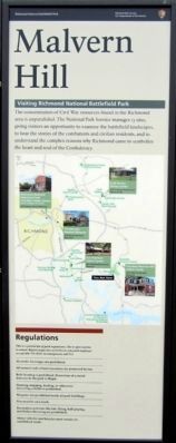
Visiting Richmond National Battlefield Park
The concentration of Civil War resources found in the Richmond area is unparalleled. The National Park Service manages 13 sites, giving visitors an opportunity to examine the battlefield landscapes, to hear the stories of the combatants and civilian residents, and to understand the complex reasons why Richmond came to symbolize the heart and soul of the Confederacy.
Regulations
This is a partial list of park regulations. Site is open sunrise to sunset. Report suspicious activities to any park employee or call 804-795-5018. In emergencies call 911.
Alcoholic beverages are prohibited.
All natural and cultural resources are protected by law.
Relic hunting is prohibited. Possession of a metal detector in the park is illegal.
Hunting, trapping, feeding, or otherwise disturbing wildlife is prohibited.
Weapons are prohibited inside all park buildings.
Pets must be on a leash.
Recreation activities like kite-flying, ball-playing, and frisbee throwing are prohibited.
Motor vehicles and bicycles must remain on established roads.
(center panel)
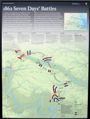
1862 Seven Days’ Battles
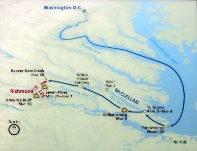
No military campaign had more influence on the course of the Civil War than these Seven Days’ battles. George B. McClellan’s army of more than 100,000 Union soldiers landed at Fort Monroe in spring of 1862, and fought its way up the peninsula. By mid-May the Army of the Potomac lay on the outskirts of Richmond, hoping to capture the capital of the Confederacy and perhaps end the war. If that strategy succeeded the nation might be reunified, but without abolition of slavery. Confederate General Robert E. Lee chose not to wait for the Federal army’s next move. Instead he seized the initiative, and on June 26 advanced across the Chickahominy River with nearly 45,000 soldiers. That action opened a week-long series of battles that resulted in the Union army retreating to the banks of the James River. With Richmond secure, Lee’s army moved north, defeated Union forces at Cedar Mountain and Second Manassas (Bull Run), and then marched toward Maryland and the first invasion of the North.
June 26
Lee massed much of his own Confederate army at Chickahominy Bluff and surged over the river in a combined operation with Thomas J. “Stonewall” Jackson.
Beaver Dam Creek
Later that afternoon Lee’s men struck a well positioned piece of the Federal army at Beaver Dam Creek. His attack failed, but Jackson’s presence above the creek forced McClellan’s men away overnight.
June 27
McClellan decided to move to a new base on the James River, but his rearguard at Gaines’ Mill barely escaped destruction when Lee’s Confederates launched an all-out attack, triggering the second and largest battle of the Seven Days.
June 28
McClellan organized his retreat and achieved a head start in what would become a race to the James River. Meanwhile, Lee shifted from protecting Richmond to pursuing and defeating the Union army. A Confederate probe at Gouldin’s Farm, south of the Chickahominy River, produced a small battle.
June 29
Lee pushed his men forward against the Union army’s rear at Savage’s Station, on the Richmond & York River Railroad. The inconclusive battle there produced 1,400 casualties and temporarily slowed the progress of McClellan’s retreat.
June 30
Confederate columns pursued the Union army. A vicious battle at Glendale (or Frayser’s Farm) gave Lee his best opportunity of the campaign, but the determined resistance of McClellan’s subordinates kept the line of retreat open.
July 1
Malvern Hill
McClellan’s army took up a strong defensive position atop Malvern Hill. Poorly coordinated Confederate attacks resulted in a decisive Union victory.
July 2
The Confederates pursued the Northern army to its new base at Harrison’s Landing. Lee determined no offensive opportunities remained, and ended his campaign to drive foe away from Richmond, concluding the Seven Days’ battles.
(right panel)
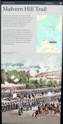
Malvern Hill Trail
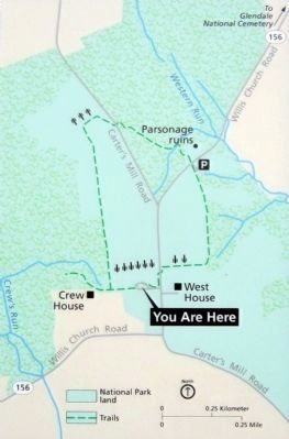
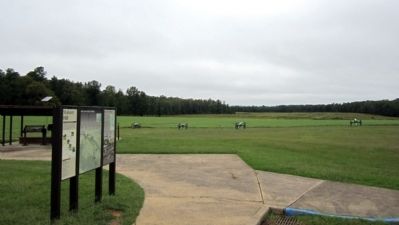
This one-and-a-half mile trail reveals one of the best preserved battlefields in the nation. More than a dozen signs describe the landscape, the progress of the battle, and its various landmarks. Parking lots at the crest of Malvern Hill and at the Parsonage ruins provide access points.
If you begin at the Parsonage, you will walk the disastrous Confederate assault in the footsteps of the participants before reaching the Union line and circling back past the West House. If you start your walk at the crest of the hill, among the now-silent Federal cannon, you will experience the strength of the position before walking the route of the Confederate attacks.
Erected 2011 by Richmond National Battlefield Park.
Topics. This historical marker is listed in this topic list: War, US Civil. A significant historical year for this entry is 1862.
Location. 37° 24.775′ N, 77° 15.005′ W. Marker is in Henrico, Virginia, in Henrico County. Marker can be reached from Willis Church Road (Virginia Route 156) 0.2 miles north of Carters Mill Road (County Road 606). Marker is in the Malvern Hill Unit of Richmond National Battlefield Park. Touch for map. Marker is at or near this postal address: 9175 Willis Church Road, Henrico VA 23231, United States of America. Touch for directions.
Other nearby markers. At least 8 other markers are within walking distance of this marker. A Splendid Field of Battle (a few steps from this marker); a different marker also named Malvern Hill (a few steps from this marker); Southern Valor vs. Union Firepower (a few steps from this marker); Union Firepower (within shouting distance of this marker); Battlefield of Malvern Hill (about 300 feet away, measured in a direct line); Battlefield Landscape (about 300 feet away); Seven Days Battles (about 400 feet away); The West House (about 400 feet away). Touch for a list and map of all markers in Henrico.
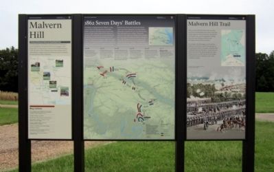
More about this marker. On the left panel is a map of Civil War sites managed by the Richmond National Battlefield Park.
On the center panel is a map of the Federal advance up the Peninsula and a map of the Seven Days’ Battles.
On the right panel is an image with the caption, "This 1800s woodcut emphasized the role of artillery at Malvern Hill."
Related marker. Click here for another marker that is related to this marker. Old Marker At This Location titled "Richmond Battlefield".
Also see . . .
1. The Battle of Malvern Hill. Richmond National Battlefield Park (Submitted on September 7, 2011.)
2. Malvern Hill. Civil War Trust (Submitted on September 7, 2011.)
3. Malvern Hill Battlefield Podcast. Richmond National Battlefield Park (Submitted on September 7, 2011.)
Credits. This page was last revised on November 5, 2021. It was originally submitted on September 7, 2011, by Bernard Fisher of Richmond, Virginia. This page has been viewed 851 times since then and 20 times this year. Photos: 1, 2, 3, 4, 5, 6, 7. submitted on September 7, 2011, by Bernard Fisher of Richmond, Virginia.
