Fort Trumbull in New London in New London County, Connecticut — The American Northeast (New England)
American Revolution
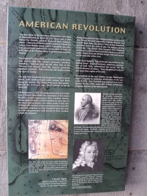
The first shots of the American Revolution were fired in Massachusetts in April of 1775, more than a year before the thirteen colonies declared their independence. Connecticut needed fortifications to defend the colony from British attack, and in November the colonial government authorized construction of forts on both sides of the Thames River to protect New London Harbor.
The original Fort Trumbull, built just north of this fort, was named after the colony’s governor, Jonathan Trumbull. The fort built on the other side of the Thames was named after the deputy governor, Matthew Griswold. Fort Griswold still stands across the river in Groton.
The first Fort Trumbull was designed to repel a naval attack, with earth-and-sod walls sixteen feet thick facing the harbor. The fort lacked such solid protection on the landward side, which proved to be its downfall.
On September 6, 1781, six weeks before the end of the war, a British fleet under the command of the traitor Benedict Arnold approached New London Harbor. About eight hundred, soldiers landed on each side of the river, approximately two miles south of this site. Of those who landed on the left bank of the river, five companies marched on Fort Trumbull from the rear, and the rest proceeded with Arnold to New London, which they burned.
Being outnumbered and without earthen walls or cannon facing the land approach, Captain Shapley and twenty-three men, the patriot force at Fort Trumbull, retreated across the river to join the defense of Fort Griswold. The British then occupied Fort Trumbull and began to fire on Fort Griswold, which was already under attack from the British troops who had landed on the east side of the river.
After hard fighting, Fort Griswold succumbed to the British forces. Colonel Ledyard, American commander of both forts, surrendered his sword, but the British showed no mercy. They slaughtered Ledyard and more than eighty of his men.
As president of the new nation, George Washington urged Congress to authorize fortification of the seacoast in 1794. Fort Trumbull was repaired and reconfigured in the 1790s under this federal fortification program, known as the First System.
Erected by Fort Trumbull State Park.
Topics. This historical marker is listed in this topic list: War, US Revolutionary. A significant historical month for this entry is April 1775.
Location. 41° 20.609′ N, 72° 5.605′ W. Marker is in New London, Connecticut, in New London County. It is in Fort Trumbull. Marker can be reached from East Street when traveling south. Marker is located inside the fort at Fort Trumbull State Park. Touch for map. Marker is in this post office area: New London CT 06320, United States of America. Touch for directions.
Other nearby markers. At least 8 other markers are within walking distance of this marker. War of 1812 (here, next to this marker); Fort Interiors (here, next to this marker); The Third System (here, next to this marker); Civil War (a few steps from this marker); Coast Guard (a few steps from this marker); Post Civil War to 1910 (a few steps from this marker); “Aim, Load, Fire” (a few steps from this marker); Scientific Research (within shouting distance of this marker). Touch for a list and map of all markers in New London.
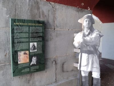
More about this marker. A map at the lower left of the marker includes the caption “This 1781 map shows the routes taken by Benedict Arnold’s troops during the attack on New London and Groton. The British ships are depicted at the mouth of the river. Fort Trumbull and New London appear on the west bank of the river and Fort Griswold appears on the east bank.”
The lower right of the marker features a Detail of a portrait of Jonathan Trumbull, courtesy of Connecticut Historical Society. It has a caption of “Fort Trumbull was named after the governor of Connecticut, Jonathan Trumbull. Trumbull, who was elected by the colonists rather than appointed by the king, was the only governor in any of the thirteen colonies to support the Revolution.”
Above this is a picture of Benedict Arnold with the caption “Benedict
Arnold was a native of Norwich, Connecticut, which is only twelve miles upriver from New London. In the early years of the war he distinguished himself as a patriot commander in several battles, such as Ridgefield in western Connecticut, and Ticonderoga and Saratoga in New York. Yet in 1780, he betrayed the revolutionary cause by arranging to deliver West Point, which was a strategically crucial stronghold on the Hudson River, to the British. The treacherous plot failed, but Arnold had turned traitor in return for money. He became a brigadier general in the British army and the following year commanded the British attack on New London and Groton.”
Also see . . .
1. History of Fort Trumbull. Friends of Fort Trumbull website. (Submitted on October 13, 2011, by Bill Coughlin of Woodland Park, New Jersey.)
2. Battle of Groton Heights. Friends of Fort Griswold website. (Submitted on October 13, 2011, by Bill Coughlin of Woodland Park, New Jersey.)
Credits. This page was last revised on February 10, 2023. It was originally submitted on October 13, 2011, by Bill Coughlin of Woodland Park, New Jersey. This page has been viewed 631 times since then and 10 times this year. Photos: 1, 2, 3. submitted on October 13, 2011, by Bill Coughlin of Woodland Park, New Jersey.


