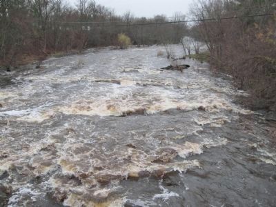
Cadott in Chippewa County, Wisconsin — The American Midwest (Great Lakes)
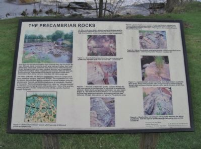
The Precambrian Rocks
The oldest rocks here are dark gray amphibolites, which are composed of black amphibole and gray plagioclase feldspar. The amphibolites are "cut" by masses of pinkish gray granite composed of creamy feldspars and gray, glassy quartz. You can see unassimilated pieces of amphibolite "floating" in the granite. The resulting comprise rock is called an "intrusion breccia". You will also see younger granites cutting older ones. Some of the granites, called pegmatites, are very coarse-textured, with big crystals of pinkish feldspar and quartz.
Figure 2 --- Sketch of an intrusion breccia with fragments of deformed granite and amphibolite.
All of the rocks show a distinct layering or foliation which is produced by solid-state flowage of crush debris under extremely high shearing stress and/or recrystallization under compression.
Figure 3 --- Shear-folded compositional layering in contaminated granite. Key highlights axial trace of small fold. Location #2
Figure 4 --- Sheared, contaminated granite; Location #3 Note the gray color caused by contaminated of the granite by amphibolitic minerals. Notice that in some places the foliation has been folded [Figure 4]. This indicates that the foliation was produced during an initial high-temperature-pressure deformation and then later deformed. Multiple deformations are typical of Precambrian rocks.
Figure 5 --- A large fragment or "xenolith" of dark amphibolite in coarse granite contains folded granite stringers similar in composition to the enclosing granite. This relationship suggests defromation of the fragment after intrusion of some of the granite Location #4.
Figure 6 --- Veined Precambrian amphibolite xenolith cut by granite which shows deformation fabric – a thin layering called "foliation". Location: #5
Figure 7 --- Laminated dark granite containing much disseminated amphibolite [dark gray]. Some of this granular fabric was produced by intense shearing along a west-northwest trending fault zone after granite intrusion at 1,800 mya. Location #6
Figure 8 --- Granite dikes and stringers cutting highly deformed and altered amphibolite. Note two ages of granite dikes [granite cutting older granite]. Location #7
Created by: Dr. Paul Myers
Geology Department
University of Wisconsin-Eau Claire
In the Memory of Tim McConville
Donated by the McConville Family
Erected 2004 by Dr. Paul Myers; donated by the McConville Family.
Topics. This historical marker is listed in this topic list: Natural Features. A significant historical year for this entry is 1850.
Location. Marker has been reported missing. It was located near 44° 57.225′ N, 91° 9.053′ W. Marker was in Cadott, Wisconsin, in Chippewa County. Marker was at the intersection of North Main Street and West Yellow Street, on the right when traveling north on North Main Street. Touch for map. Marker was in this post office area: Cadott WI 54727, United States of America. Touch for directions.
Other nearby markers. At least 8 other markers are within 2 miles of this location, measured as the crow flies. Cadotte Trading Post Site (approx. 0.2 miles away); Cadott Centennial (approx. 0.2 miles away); The Great Northern Pine of Wisconsin (approx. 0.2 miles away); The Cadotte Fur Traders (approx. 0.2 miles away); Cadott Hub and Spoke Factory (approx. ¼ mile away); The Gravesite of Lansing A. Wilcox (approx. 0.9 miles away); Wisconsin Veterans Tribute (approx. 1.2 miles away); Citizen Soldier Monument (approx. 1.2 miles away). Touch for a list and map of all markers in Cadott.
Additional commentary.
1. mya
Used in the text, "mya" indicates million years ago.
— Submitted November 29, 2011.
Credits. This page was last revised on July 16, 2022. It was originally submitted on November 29, 2011, by Keith L of Wisconsin Rapids, Wisconsin. This page has been viewed 748 times since then and 5 times this year. Photos: 1, 2. submitted on November 29, 2011, by Keith L of Wisconsin Rapids, Wisconsin. 3. submitted on July 16, 2022, by Jim Schaettle of Madison, Wisconsin. 4, 5. submitted on November 29, 2011, by Keith L of Wisconsin Rapids, Wisconsin.
