Near Coleville in Mono County, California — The American West (Pacific Coastal)
Golden Gate Mine
[Side-bar, top left]
General History
This gold mining claim was first discovered in 1898 and expanded by further discoveries of “veins of minimal bearing quartz” in the following years. In 1900 J.E. Canter discovered 1500 linear feet by 600 feet wide of load and proclaimed that this claim will be known as “Golden Gate”. Between 1900 and 1902 the mine was purchased by Ed F. Donovan and Joe A. Brown and they began constructing tunnels, trails, chutes and reforming the wagon road. Brown and Donovan owned and operated the mine from 1902 to 1927 even though the mine was idle through much of the latter years.
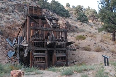
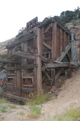
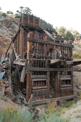
Miners hand drilled ore from quartz veins within five adit tunnels ranging from 300 to 1800 feet and the shipped it down a 2300 foot aerial tramway to the ten stamp mill you are looking at today. The water powered stamp mill pulverized the ore and then extracted the gold using mercury. The Golden Gate Mine produced the only gold in the West Walker River Mining District. In 1908 the mine boasted a net of more that $12 a ton causing the Mono County industry report to claim, The Golden Gate is a producer of great merit.” Between September 1912 and April 1913, six thousand eight-hundred and forty eight tons of ore were crushed yielding $33,646. This is quite an accomplishment considering the mill and most of the buildings were destroyed numerous times by avalanches.
[End side-bar]
[Bottom left]
The Storm of 1911
Two devastating avalanches occurred in March 1911. The first slide at Golden Gate destroyed the bunk house, stable and intake to the water plant. Some men sustained minor injuries and a horse broke its leg. A second slide a week later took out the boarding house. An avalanche four years prior had destroyed the mill and buildings. These were then rebuilt 200 feet from what was believed to be the only hill that was avalanche prone, yet the heavy snow of 1911 disproved the miners’ calculations and ended up causing $759 in damage. The storm of 1911 also caused havoc elsewhere. Nine miners died, including the owner of the Masonic mine[,] in avalanches at Copper Mountain, Masonic and Lundy. It was estimated that 4,000,000 tons of snow slid off of Copper Mountain in that fateful March.
[Side-bar bottom center]
How Does a Stamp Mill Work?
A stamp could weigh between 850 and 2,000 pounds.
Stamp mills became popular in the Sierra after the Sawyer Act of 1883 that outlawed hydraulic mining and used in lode and hard rock mining for gold, silver, and copper. A stamp
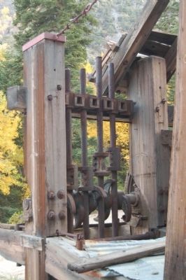
mill is comprised of a set of heavy wooden or metal beams that are loosely held vertically in a frame so that they can be raised and lowered like battering rams to crush ore. Each frame and beam set is called a “stamp”. A stamp could weigh between 850 and 2,000 pounds. Cams on the frame lift and release the stamps, which fall onto the ore, similar to how cam lifts and closes valves in an internal combustion engine. The crushed ore is then either washed over mercury coated sheets or combined with mercury in a “battery box” where gold sticks to the mercury and is separated from the quartz ore. The gold and mercury combination is called an amalgam. The pure gold is separated from the amalgam by heating and evaporating the mercury and then forming into gold blocks.
[End side-bar]
[Side-bar top right]
Preserving the Past for the Future
Stabilization of the Gold Gate Mill
The Golden Gate Mill is the last standing stamp mill on Public Land administered by the Bureau of Land Management, Bishop Field Office (BLM). To preserve this important piece of our cultural and historical heritage for current and future generations, the BLM began stabilization efforts at the mill in October 2005. In partnership with a National Park Service historic structure stabilization crew, three months were spent removing 90 years worth of rock slide rubble, assessing and mitigating the damage. The mill’s post and beam superstructure had been severely compromised by the elements and time. Measures have been taken to arrest the severe decay and to stabilize the structure so that the mill and the story that it holds may be preserved and told for generations to come.
[Photo captions:]
[top] Mill Damage, [bottom] Before Stabilization. [End side-bar]
[Bottom left]
Gold Fever
As you stand at this site today and observe this old stamp mill, which has survived for over a hundred years, imagine the early miners who plied a living from this hard rock. They represented many nationalities, but all appeared as one, covered with the dust and grit of their endeavor. Imagine the crushing sound of the 10 stamps that rang to the valley below. Imagine the mill and mine above teeming with the activities and lives of hard rock miners. A ‘small city’ at this site once bustled with the sounds, anticipation and the energy of ‘gold fever’. The mill, the cookhouse and maintenance shed below, and the loading tram and mine shafts above are the only remnants of a formative and flamboyant period of western history that include the story of the Golden Gate Mine and Mill. We hope you consider and enjoy the story that they hold!
[Photo captions, clockwise from the stamp mill illustration at twelve o’clock]
Imagine the loud crushing sound of 900 pound stamps slamming into rock and grinding it into dust. The Golden Gate stamp mill could be heard ringing throughout Walker Valley.
“The ceaseless dance of the stamps pulverized the rock to powder, and a stream of water that trickled into the battery turned it to a creamy paste.” Mark Twain Stamp Mill Before Stabilization. “Nature’s work of removing the puny intrusions of mankind will advance without interference and the place will become almost as if it had never been. Bits of glass glittering in the sand, a scrap of rusted iron, a partly filled old excavation, an old ore dump or the yawning mouth of a tunnel wil cause some wanderer to ‘wonder what this camp was.’” W.A. Chalfant
After Stabilization Maintenence [sic] Shed
Cook and Bunk House
Stamps
Stamp Mill in 2005
Stamp Mill in 1917
Please help us Preserve for the Future. For more information about this site or other BLM stabilization projects please contact the Bishop Field Office at 351 Pacu Lane, Suite 100, Bishop CA 93514, ph: 760-872-5030.
Protect our National and Cultural Heritage. Please do not collect or remove artifacts and report vandalism. Thank you.
Erected 2006 by Bureau of Land Management.
Topics. This historical marker is listed in this topic list: Industry & Commerce. A significant historical month for this entry is March 1911.
Location. 38° 30.844′ N, 119° 31.906′ W. Marker is near Coleville, California, in Mono County. Marker is on Golden Gate Road. From Highway 395, half-way between Walker and Coleville, turn west on Mill Canyon Road. Keep right onto Golden Gate Road. The marker is approximately 3 miles from Highway 395. Touch for map. Marker is in this post office area: Coleville CA 96107, United States of America. Touch for directions.
Other nearby markers. At least 8 other markers are within 14 miles of this marker, measured as the crow flies. A different marker also named Golden Gate Mine (a few steps from this marker); The C-130 Crew (approx. 2.6 miles away); Flag on Centennial Bluff (approx. 3.1 miles away); Coleville (approx. 4 miles away); Topaz Post Office (approx. 6.4 miles away); Mountain Warfare Training Center (approx. 10.9 miles away); Sonora Mono Toll Road (approx. 14 miles away); Sonora Pass (approx. 14 miles away). Touch for a list and map of all markers in Coleville.
Also see . . . East of the Sierra: Golden Gate Mine. California Gold Explorers entry (Submitted on September 20, 2020, by Larry Gertner of New York, New York.)
Credits. This page was last revised on September 20, 2020. It was originally submitted on December 1, 2011, by Barry Swackhamer of Brentwood, California. This page has been viewed 1,484 times since then and 56 times this year. Photos: 1, 2, 3, 4, 5. submitted on December 1, 2011, by Barry Swackhamer of Brentwood, California. • Syd Whittle was the editor who published this page.


