Cape Elizabeth in Cumberland County, Maine — The American Northeast (New England)
Looking East
Casco Bay
[Header Information]
Portland Harbor: Ice-free, 25' deep at low tide
Export/Import: Paper, Electronics, Foresty Products, Seafood, Oil & Gas
Winds: Southerly in Summer, Northerly in Winter
Commercial Fishing Fleet: 150
Peaks Island: Most populated island in Casco Bay, located 3 miles from Portland
Ragged Island: Poet Edna St. Vincent Millay purchased the island in 1933.
Halfway Rock: The Halfway Rock Lighthouse is located in Casco Bay, midway between Cape Elizabeth and Small Point.
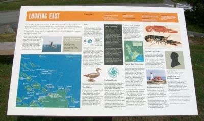
The name of the Casco Bay "Calendar Islands" is derived from the eighteenth-century myth that there were "as many islands as there are days in the year." According to the United States Coast Pilot, there are 136 islands; other sources place the count at slightly over 200.
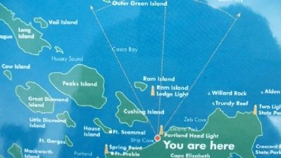
Ram Island Ledge Light
Ram Island Ledge Light is a 72-foot granite tower built in 1905 on a narrow ledge of rocks that threatens the entrance to Portland Harbor. It is nearly a twin of the Graves Light in Boston Harbor, which was built around the same time. Ram Island Ledge can be easily seen from this location.
Casco Bay is Home to Six Lighthouses
Bug Light • Halfway Rock Light • Portland Head Light • Ram Island Ledge Light • Spring Point Ledge Light • Two Lights
Tides
Daily tides are one of the most reliable phenomena in the world. Tides are the rise and fall of water throughout the Earth's oceans created by the Moon's (and, to a lesser extent, the Sun's) gravitational pull. In most places, there are two high tides and two low tides each day, with 6 hours and 12.5 minutes between each high and low. High tides happen on the opposite sides of the Earth at the same time.
Tidal height changes dramatically along the Gulf of Maine, which stretches from Cape Cod to the tip of Nova Scotia. At the southern end, tides seldom range over 4 feet (little more than 1 meter), but they increase constantly as they go eastward. Immediately to the north of the Cape there is a tidal range of 7 to 10 feet (2-3 meters); near Passamaquoddy Bay they reach 28 feet (8.5 meters);and tides reach as high as 50 feet (15 meters) in the Bay of Fundy - the highest recorded tides in the world.
Early Casco Bay
There are two theories on the origin of the name "Casco Bay." One is based on the name given the bay by Portuguese explorer Esteban Gómez, who explored the Maine coast in 1525. He called it "Bahia de Cascos" (Bay of Helmets, based on the bay's shape). The second theory is based on "Aucocisco," the Abenaki name for the bay, which means "place of herons" (sometimes translated as 'muddy').
The bay is home to abandoned military fortifications dating from the War of 1812 through World War II; during World War II, Casco Bay served as an anchorage for US Navy ships.
Eagle Island, now a State Historic Site, was the summer home of Arctic explorer Robert Peary.
Recreational Boating
Boating is a popular summer activity. Many boaters "island hop," while others fish and others just enjoy the sights. Recreational boats may also be chartered for fishing. Casco Bay is home to many marinas, stretching from Portland to Phippsburg (Sebasco). Many marinas offer food, fuel, and dockage.
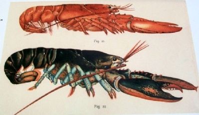
The Maine Lobster
A record catch of over 57 million pounds of this delicacy was landed from Maine lobster traps in 2000.
A lobster sheds its shell in order to grow. A one-pound lobster may be from five to seven years old, having shed about 25 times. Lobsters grown throughout their lives, and it is not unusual for a lobster to live for more than one hundred years.
Portland Head Light
Built during the presidency of George Washington, Portland Head Light is the oldest of Maine's 66 lighthouses, and is said to be the most photographed lighthouse in America.
For nearly two hundred years the responsibility for maintaining and monitoring Portland Head Light fell to the lighthouse keeper. In 1991, a Museum and gift shop were created in the keeper's former home.
Longfellow and Portland Head
Poet Henry Wadsworh Longfellow, who was born in Portland and graduated from Bowdoin College in 1825, was a frequent visitor to Portland Head Light in his younger years. Longfellow's poem "The Lighthouse" was probably inspired by his many hours here.
"The Lighthouse"
The rocky ledge runs far out into the sea
And on its outer point, some miles away,
The lighthouse lifts its massive masonry,
A pillar of fire by night, of cloud by day.
Henry Wadsworth Longfellow
Portland Pilots
The ice-free Portland Harbor offers secure anchorage to deep-draft vessels in all weather. Portland Pilots assist vessels in safely entering the harbor. In addition to utilizing the latest navigational technology, the Pilots typically use "dead reckoning" in good visibility. They take a sighting off of the Cathedral on Congress Street in Portland. This bearing takes them directly into the harbor from just outside of Portland Head Light.
Pilotage is compulsory for all foreign vessels and US vessels under register in the foreign trade drawing over nine feet.
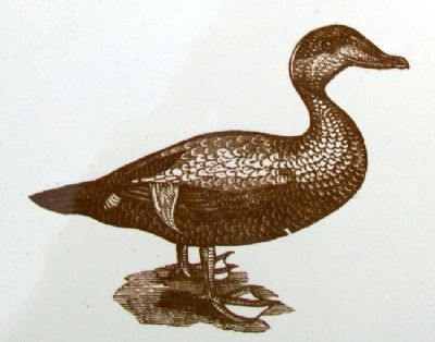
Sea Ducks
The Common Eider is characterized by its bulky shape and large, wedge-shaped bill. The male is unmistakable, with its black and white plumage and green nape. The female is brown, but can still be readily distinguished from all ducks, except other eider-species, on the basis of size and head shape. The Common Eider's call is a pleasant "ah-ooo."
Topics and series. This historical marker is listed in this topic list: Waterways & Vessels. In addition, it is included in the Lighthouses series list. A significant historical year for this entry is 1933.
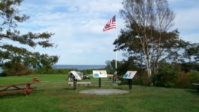
Location. 43° 37.433′ N, 70° 12.674′ W. Marker is in Cape Elizabeth, Maine, in Cumberland County. Marker is on the hill, about 1000 feet WNW of Portland Head Light, in Fort Williams Park, off Shore Road. Touch for map. Marker is in this post office area: Cape Elizabeth ME 04107, United States of America. Touch for directions.
Other nearby markers. At least 8 other markers are within walking distance of this marker. Looking South (here, next to this marker); Looking North (here, next to this marker); Battery Hobart (about 400 feet away, measured in a direct line); Battery Blair (about 500 feet away); Mining Casemate (about 500 feet away); Fort Williams (about 600 feet away); Daily Life (about 600 feet away); Civilian Conservation Corps (about 600 feet away). Touch for a list and map of all markers in Cape Elizabeth.
Also see . . . Casco Bay History. (Submitted on December 11, 2011, by William Fischer, Jr. of Scranton, Pennsylvania.)
Credits. This page was last revised on December 8, 2021. It was originally submitted on December 11, 2011, by William Fischer, Jr. of Scranton, Pennsylvania. This page has been viewed 694 times since then and 8 times this year. Photos: 1, 2, 3, 4, 5, 6. submitted on December 11, 2011, by William Fischer, Jr. of Scranton, Pennsylvania. 7. submitted on November 28, 2021, by Craig Doda of Napoleon, Ohio.
