Locust Grove in Mayes County, Oklahoma — The American South (West South Central)
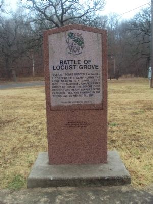
Battle of Locust Grove
Erected 1995 by Oklahoma Historical Society. (Marker Number 160.)
Topics and series. This historical marker is listed in these topic lists: Native Americans • War, US Civil. In addition, it is included in the Oklahoma Historical Society series list. A significant historical month for this entry is July 1961.
Location. 36° 11.889′ N, 95° 8.998′ W. Marker is in Locust Grove, Oklahoma, in Mayes County. Marker is on Scenic Route 412 (Scenic U.S. 412). This marker is on the right side of the road as you travel eastbound on Scenic US 412 in the Locust Grove Park. Touch for map. Marker is in this post office area: Locust Grove OK 74352, United States of America. Touch for directions.
Other nearby markers. At least 5 other markers are within 12 miles of this marker, measured as the crow flies. Chouteau's Post (approx. 6˝ miles away); Union Mission (approx. 9.2 miles away); Union Mission and Cemetery (approx. 9.2 miles away); Nathaniel Hale Pryor (approx. 12 miles away); Veterans Memorial (approx. 12 miles away).
Credits. This page was last revised on June 16, 2016. It was originally submitted on February 5, 2012, by Michael Manning of Woodlawn, Tennessee. This page has been viewed 1,235 times since then and 50 times this year. Photos: 1, 2, 3. submitted on February 5, 2012, by Michael Manning of Woodlawn, Tennessee. • Craig Swain was the editor who published this page.
Editor’s want-list for this marker. A photo of the marker and the surrounding area in context. • Can you help?


