Bolivar in Jefferson County, West Virginia — The American South (Appalachia)
Bolivar Heights Trail
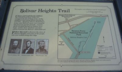
Union and Confederate soldiers transformed these fields into campgrounds full of dingy tents, smoky campfires and boiling kettles during the Civil War. Shouting officers drilled their troops until Bolivar's grass was trampled into precision parade grounds. Cannon shells shrieked during two battles here. Later, somber faces watched comrades' coffins lowered into Bolivar's disturbed soil.
Follow this trail to discover the story of Bolivar Heights and some of the people who walked along this ridge.
"The heights west of Bolivar must be strengthened."
Col Thomas J. Jackson, CSA
Letter to Maj. Gen. Robert E. Lee, CSA
May 7, 1861
Topics. This historical marker is listed in this topic list: War, US Civil. A significant historical month for this entry is May 1843.
Location. 39° 19.424′ N, 77° 45.675′ W. Marker is in Bolivar, West Virginia, in Jefferson County. Marker is at the intersection of Whitman Avenue and Prospect Avenue (County Road 27/1), on the left when traveling north on Whitman Avenue. Located at the trail head for the Bolivar Heights walking trail. Touch for map. Marker is at or near this postal address: 47 Spring Street, Harpers Ferry WV 25425, United States of America. Touch for directions.
Other nearby markers. At least 8 other markers are within walking distance of this marker. Harpers Ferry (here, next to this marker); Historic Heights (here, next to this marker); Facing the Enemy (a few steps from this marker); Battle of Harpers Ferry / Union Stronghold (a few steps from this marker); Closing the Doors (within shouting distance of this marker); The First Year of War (within shouting distance of this marker); Rats in a Cage (within shouting distance of this marker); Casualties of War (about 300 feet away, measured in a direct line). Touch for a list and map of all markers in Bolivar.
More about this marker. On the lower left under the text are portraits of Stonewall Jackson, Abraham Lincoln, and Philip Sheridan. On the right is a map of the trail, captioned, "The trail along this grassy hill covers only part of Bolivar Heights which runs north-south for two miles between the Potomac River and the Shenandoah River.
Related markers. Click here for a list of markers that are related to this marker. Markers along Bolivar Heights related to the Civil War activity in Harpers Ferry.
Credits. This page was last revised on April 26, 2020. It was originally submitted on February 11, 2008, by Craig Swain of Leesburg, Virginia. This page has been viewed 2,210 times since then and 32 times this year. Last updated on April 26, 2020, by Larry Gertner of New York, New York. Photos: 1, 2. submitted on February 11, 2008, by Craig Swain of Leesburg, Virginia. • Devry Becker Jones was the editor who published this page.

