Torrington in Litchfield County, Connecticut — The American Northeast (New England)
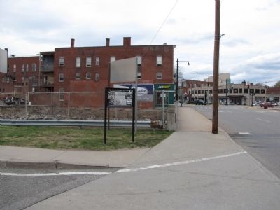
The Flood of August 19, 1955
"So numerous were the many acts of heroism, rescue of the sick and invalid, neighbors' concern for neighbors, that it would be impossible to chronicle them with slighting someone deserving of great credit." - Torrington Register, August 26, 1955
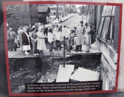
It was the worst natural disaster in Torrington's history, as two tropical storms dropped 23 inches of rain on Torrington within a period of one week. Some low-lying areas were flooded on August 18, 1955, but later that night and into the morning of August 19, fourteen more inches of rain fell on the saturated city. Residents awoke to witness the full destructive force of the Naugatuck River unleashed in a flash flood. The swiftly moving floodwaters were filled with lumber, rocks, mud and other debris which destroyed bridges, homes, businesses, and took the lives of seven Torrington residents.
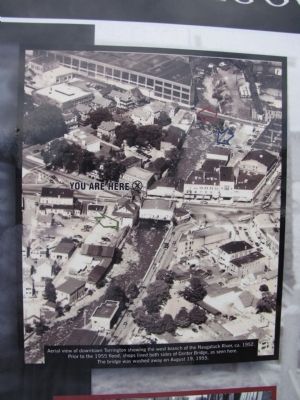
The area of downtown Torrington where you are standing was hit hard. The old Center Bridge was lined on both sides with stores until the west branch of the Naugatuck River washed them and the bridge away. From here the river swept down East Main Street filling stores with water up to a depth of six feet. The east branch of the Naugatuck River cut another path of destruction through the north end of Torrington. Industries located along both branches of the river were severely damaged and all of Torrington's utilities, phone, water, electricity, gas and sewer were out of service. Damage was estimated at 22 million dollars.
The residents of Torrington helped each other through the tragedy of the flood and the hardships of rebuilding. It would take many months before all the damage was repaired and several years to build flood control projects. Nevertheless, business owners and residents were determined to make Torrington a better place. By September 1955, life was returning to normal but for those who lived through the flood it was an unforgettable experience. Whatever the reason - the horror of that night, a personal loss, the sound of the rushing water, or the satisfaction of helping someone in need - the flood of 1955 became a defining moment in the lives of Torrington residents and in Torrington's history. Today, a cleaner and safer Naugatuck River meanders through town bearing little evidence of that horrible night in 1955.
This marker is dedicated to those Torrington residents who lost their lives in the flood of 1955.
Carmela Rose Bauchiero • Mary Bauchiero • Victor Cuatto • Gustave Jacquemin • Lena Lemire • Katherine Ruot • Erminia Zordan
Erected 2005 by Mayor Owen J. Quinn and the City of Torrington.
Topics. This historical marker is listed in these topic lists: Disasters
• Industry & Commerce • Waterways & Vessels. A significant historical month for this entry is September 1955.
Location. 41° 48.017′ N, 73° 7.293′ W. Marker is in Torrington, Connecticut, in Litchfield County. Marker is at the intersection of Litchfield Street (U.S. 202) and South Main Street, on the left when traveling north on Litchfield Street. Marker is located at the south end of the Naugatuck River bridge just north of the Torrington Library parking lot and Coe Memorial Park. Touch for map. Marker is in this post office area: Torrington CT 06790, United States of America. Touch for directions.
Other nearby markers. At least 8 other markers are within walking distance of this marker. Torrington Soldiers Memorial (within shouting distance of this marker); Coe Memorial Park (within shouting distance of this marker); Torrington Veterans Memorial (about 400 feet away, measured in a direct line); VFW 155mm Howitzer (about 500 feet away); Torrington Vietnam Monument (about 600 feet away); Torrington (approx. 0.2 miles away); Hotchkiss-Fyler House (approx. ¼ mile away); 1902 Constitutional Convention Pin Oak Tree (approx. 0.3 miles away). Touch for a list and map of all markers in Torrington.
Additional commentary.
1. 1955 Flood marker Torrington,Ct.
I live near this and the
Photographed By Lee Hattabaugh, April 15, 2012
3. The Flood of August 19, 1955 Marker
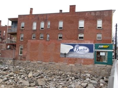
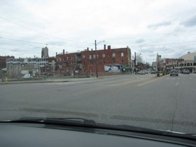
Looking north across the bridge driving from Main Street in to the intersection. Marker is seen to the left and the building across the bridge survived the flood but shows damage from where the adjacent building was damaged/removed.
— Submitted August 6, 2016, by Kevin W. Titus of Canaan, Ct..
Photographed By Lee Hattabaugh, April 15, 2012
4. shops on the west side of Center Bridge
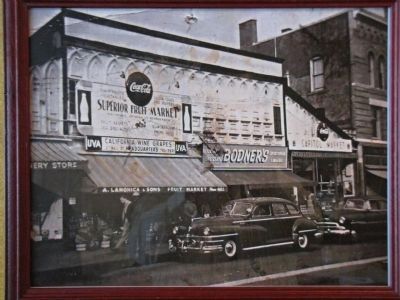
This photo shows a couple of the shops that were located on the west side of Center Bridge prior to the flood of 1955. In the center is "A. LaMonica & Sons Fruit Market". Within a week after the flood, the LaMonica's relocated their store a few blocks away to Migeon Avenue and today the family operates a successful restaurant and catering business in the same location. This photo was provided by the LaMonica family.
Photographed By Lee Hattabaugh, April 15, 2012
7. Marker photo, lower right
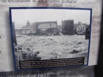
Raging flood waters along the west branch of the Naugatuck River during the morning of August 19, 1955. This view, looking downstream, shows the roof of the shops on Center Bridge still spanning the river. To the right of the bridge is the back of the Workman-Rawlinson building which suffered extensive damage and was later torn down.
Photographed By Lee Hattabaugh, April 15, 2012
8. Marker photo, upper right
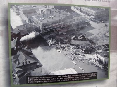
Downtown Torrington, August 1955, after flood waters subsided and cleanup efforts began. In this photo, only the store roof on the west side of Center Bridge remains. Central Hotel, the building in the lower left corner, was demolished as a result of flood damage.
Credits. This page was last revised on September 20, 2016. It was originally submitted on April 16, 2012, by Lee Hattabaugh of Capshaw, Alabama. This page has been viewed 1,346 times since then and 25 times this year. Photos: 1, 2, 3, 4, 5, 6, 7, 8, 9. submitted on April 16, 2012, by Lee Hattabaugh of Capshaw, Alabama. • Bill Pfingsten was the editor who published this page.

