Greenbrier West in Chesapeake, Virginia — The American South (Mid-Atlantic)
Civil War Anchor
The Waterways
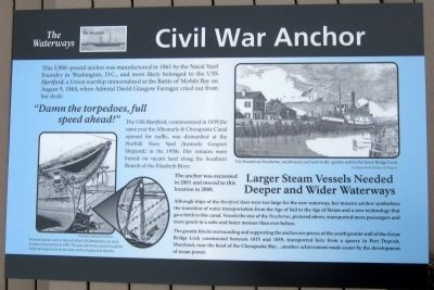
“Damn the torpedoes, full speed ahead!”
The USS Hartford, commissioned in 1859, the same year the Albemarle & Chesapeake Canal opened for traffic, was dismantled at the Norfolk Navy Yard (formerly Gosport Shipyard) in the 1950s. Her remains were buried on vacant land along the Southern Branch of the Elizabeth River.
Larger Steam Vessels Needed Deeper and Wider Waterways
Although ships of the Hartford class were too large for the new waterway, her massive anchor symbolizes the transition of water transportation from the Age of Sail to the Age of Steam and a new technology that gave birth to this canal. Vessels the size of the Newberne, pictured above, transported more passengers and more goods in a safer and faster manner than ever before.
The granite blocks surrounding and supporting the anchor are pieces of the south granite wall of the Great Bridge Lock constructed between 1855 and 1859, transported here from a quarry in Port Deposit, Maryland, near the head of the Chesapeake Bay…another achievement made easier by the development of steam power.
Erected 2012 by Great Bridge Battlefield & Waterways History Foundation.
Topics. This historical marker is listed in these topic lists: War, US Civil • Waterways & Vessels. A significant historical year for this entry is 1861.
Location. 36° 43.295′ N, 76° 14.422′ W. Marker is in Chesapeake, Virginia. It is in Greenbrier West. Marker can be reached from the intersection of North Battlefield Boulevard (Business Virginia Route 168) and Locks Road, on the right when traveling south. Touch for map. Marker is in this post office area: Chesapeake VA 23320, United States of America. Touch for directions.
Other nearby markers. At least 8 other markers are within walking distance of this marker. Father & Son Canal Builders (here, next to this marker); Under Two Flags (here, next to this marker); Site of the Original Causeway (within shouting distance of this marker); The Day is Our Own! (within shouting distance of this marker); First Fire (within shouting distance of this marker); Causeway Construction (within shouting distance of this marker); Great Bridge Marshall Memorial (within shouting distance of this marker); Billy Flora (within shouting distance of this marker). Touch for a list and map of all markers in Chesapeake.
More about this marker. On the lower left is a photo with the caption, "Forward quarter view of the hull of the USS Hartford in dry dock during reconstruction in 1898. The port side bower anchor is plainly visible and appears to he the same anchor displayed at this site. The anchor was excavated in 2001 and moved to this location in 2008." Courtesy National Archives
On the upper right is a photo with the caption, "The Steamboat Newberne, westbound, tied next to the granite wall in the Great Bridge Lock." Courtesy of the Library of Virginia
Also see . . . Great Bridge Battlefield & Waterways History Foundation. (Submitted on April 29, 2012, by Bernard Fisher of Richmond, Virginia.)
Credits. This page was last revised on February 1, 2023. It was originally submitted on April 29, 2012, by Bernard Fisher of Richmond, Virginia. This page has been viewed 960 times since then and 26 times this year. Photo 1. submitted on April 29, 2012, by Bernard Fisher of Richmond, Virginia.
