Near Richmond in Chesterfield County, Virginia — The American South (Mid-Atlantic)
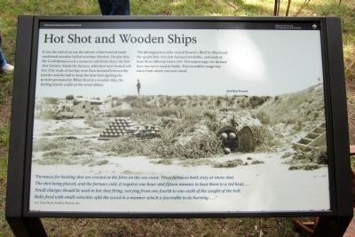
Hot Shot and Wooden Ships
The photographers who visited Drewry’s Bluff in 1865 found the quaint little hot-shot furnace irresistible, and made at least three different views of it. Not surprisingly, the furnace here was never used in battle. This incredible image was taken from where you now stand.
“Furnaces for heating shot are erected at the forts on the sea-coast. These furnaces hold sixty or more shot. The shot being placed, and the furnace cold, it requires one hour and fifteen minutes to heat them to a red heat....Small charges should be used in hot shot firing, varying from one-fourth to one-sixth of the weight of the ball. Balls fired with small velocities split the wood in a manner which is favorable to its burning....”
U.S. Army Heavy Artillery Manual, 1851
Erected 2011 by Richmond National Battlefield Park.
Topics. This historical marker is listed in these topic lists: Forts and Castles • War, US Civil. A significant historical year for this entry is 1865.
Location. 37° 25.316′ N, 77° 25.324′ W. Marker is near Richmond, Virginia, in Chesterfield County. Marker can be reached from Fort Darling Road, half a mile north of Bellwood Road. This marker is located in the Drewry’s Bluff (Fort Darling) unit of Richmond National Battlefield Park. Touch for map. Marker is at or near this postal address: 7600 Fort Darling Road, Richmond VA 23237, United States of America. Touch for directions.
Other nearby markers. At least 8 other markers are within walking distance of this marker. A Perfect Gibraltar (a few steps from this marker); Finishing Fort Drewry (a few steps from this marker); The USS Monitor (within shouting distance of this marker); Drewry’s Bluff (within shouting distance of this marker); Duty Above and Beyond (within shouting distance of this marker); May 15, 1862—The Battle of Drewry's Bluff (within shouting distance of this marker); "A Very Neat Chapel" (within shouting distance of this marker); Covered Way (within shouting distance of this marker). Touch for a list and map of all markers in Richmond.
Also see . . .
1. Drewry’s Bluff. Richmond National Battlefield Park (Submitted on May 14, 2012, by Bernard Fisher of Richmond, Virginia.)
2. Drewry’s Bluff. Civil War Richmond (Submitted on May 14, 2012, by Bernard Fisher of Richmond, Virginia.)
Credits. This page was last revised on June 16, 2016. It was originally submitted on May 14, 2012, by Bernard Fisher of Richmond, Virginia. This page has been viewed 694 times since then and 24 times this year. Photo 1. submitted on May 14, 2012, by Bernard Fisher of Richmond, Virginia.
