Kingston in Ulster County, New York — The American Northeast (Mid-Atlantic)
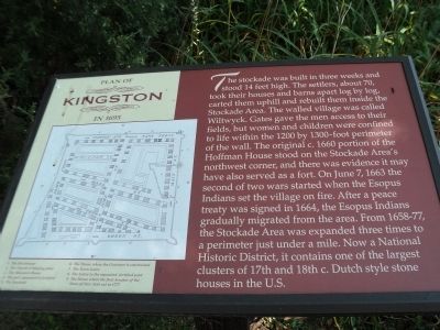
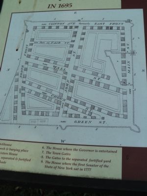
Plan of Kingston in 1695
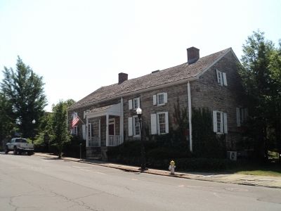
The stockade was built in three weeks and stood 14 feet high. The settlers, about 70 took their houses and barns apart log by log, carted them uphill and rebuilt them inside the Stockade Area. The walled village was called Wiltwyck. Gates gave the men access to their fields, but women and children were confined to life within the 1200 by 1300-foot perimeter of the wall. The original c. 1660 portion of the Hoffman House stood on the Stockade Area’s northwest corner, and there was evidence it may have also served as a fort. On June 7, 1663 the second of two wars started when the Esopus Indians set the village on fire. After a peace treaty signed in 1664, the Esopus Indians gradually migrated from the area. From 1658-77, the Stockade Area was expanded three times to a perimeter just under a mile. Now a National Historic District, it contains one of the largest clusters of 17th and 18th c. Dutch style stone houses in the U.S.
Topics. This historical marker is listed in these topic lists: Colonial Era • Native Americans. A significant historical month for this entry is June 1658.
Location. 41° 56.109′ N, 74° 1.378′ W. Marker is in Kingston, New York, in Ulster County. Marker is at the intersection of N Front Street and Green Street, on the right when traveling west on N Front Street. Marker is located across the street from the Hoffman House. Touch for map. Marker is in this post office area: Kingston NY 12401, United States of America. Touch for directions.
Other nearby markers. At least 8 other markers are within walking distance of this marker. Hoffman House (a few steps from this marker); a different marker also named Plan of Kingston in 1695 (within shouting distance of this marker); Medal of Honor (about 700 feet away, measured in a direct line); Kingston Academy (about 800 feet away); The Four Corners (about 800 feet away); a different marker also named Kingston Academy (approx. 0.2 miles away); The Pike Plan (approx. 0.2 miles away); The Stockade Historic District (approx. 0.2 miles away). Touch for a list and map of all markers in Kingston.
More about this marker. A map of the stockade area appears at the left side of the marker. Indicated on the map are the Blockhouse, the Church and burying place, the Ministers House, The part separated and fortified, the Stockade, the House where the Governor is entertained, the Town Gates, the Gates to the separated fortified yard, and the House where the first Senator of the State of New York sat in 1777.
Photographed By Bill Coughlin, Plan of Ki
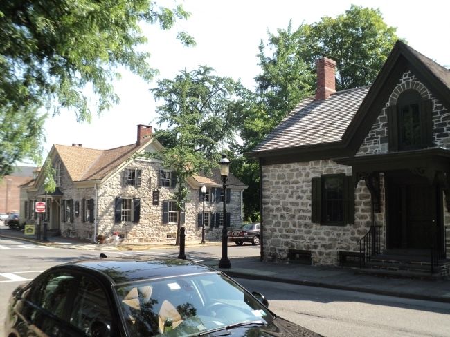
7. Houses in the Stockade Area
As mentioned on the marker, the Stockade Area still contains many 18th century Dutch style stone houses. These are located at the intersection of John Street and Crown Street. This is the only intersection in America where 18th century stone houses stand at all four corners.
Credits. This page was last revised on June 16, 2016. It was originally submitted on July 16, 2012, by Bill Coughlin of Woodland Park, New Jersey. This page has been viewed 601 times since then and 36 times this year. Photos: 1, 2, 3, 4, 5, 6, 7. submitted on July 16, 2012, by Bill Coughlin of Woodland Park, New Jersey.
