Hickory Grove in York County, South Carolina — The American South (South Atlantic)
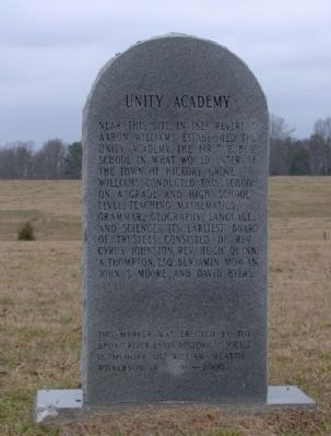
Unity Academy
This maker was erected by the Broad River Basin Historical Society in Memory of William Beattie Wilkerson, Jr. 1918-2000
Topics. This historical marker is listed in this topic list: Education. A significant historical year for this entry is 1823.
Location. 34° 59.05′ N, 81° 25.682′ W. Marker is in Hickory Grove, South Carolina, in York County. Marker is on Irene Bridge Highway. Touch for map. Marker is at or near this postal address: 2265 Irene Bridge Hwy, Hickory Grove SC 29717, United States of America. Touch for directions.
Other nearby markers. At least 8 other markers are within 7 miles of this marker, measured as the crow flies. Hickory Grove (approx. 0.8 miles away); Hickory Grove Schools (approx. 0.9 miles away); Town of Smyrna (approx. 4.2 miles away); First National Bank of Sharon (approx. 5˝ miles away); Town of Sharon / Sharon (approx. 5.6 miles away); Town of Sharon Stone Marker (approx. 5.6 miles away); Dickey - Sherer House (approx. 6 miles away); Blairsville Schools (approx. 6.7 miles away). Touch for a list and map of all markers in Hickory Grove.
Credits. This page was last revised on June 22, 2021. It was originally submitted on August 22, 2012, by Charles R. Robbins, Jr. of Rock Hill, South Carolina. This page has been viewed 528 times since then and 10 times this year. Photo 1. submitted on August 22, 2012, by Charles R. Robbins, Jr. of Rock Hill, South Carolina. • Craig Swain was the editor who published this page.
