Near Bolivar in Jefferson County, West Virginia — The American South (Appalachia)
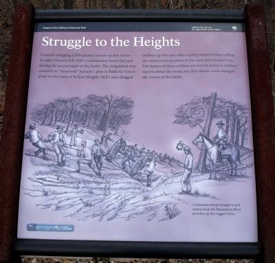
Struggle to the Heights
Harpers Ferry National Historical Park
— National Park Service, U.S. Department of the Interior —
Erected by National Park Service, U.S. Department of the Interior.
Topics. This historical marker is listed in this topic list: War, US Civil.
Location. 39° 18.677′ N, 77° 45.57′ W. Marker is near Bolivar, West Virginia, in Jefferson County. Marker can be reached from Shoreline Drive. Located on the Murphy Farm trail in the Harpers Ferry National Historical Park. Touch for map. Marker is in this post office area: Harpers Ferry WV 25425, United States of America. Touch for directions.
Other nearby markers. At least 8 other markers are within walking distance of this marker. The Fate of Harpers Ferry was sealed. (about 500 feet away, measured in a direct line); Home Becomes Battlefield (about 500 feet away); From Civil War to Civil Rights / Battle of Harpers Ferry (about 500 feet away); Holy Ground (approx. ¼ mile away); Pilgrimage (approx. ¼ mile away); A Moving Symbol (approx. ¼ mile away); The Murphy Farm (approx. ¼ mile away); Gun Position #6 (approx. 0.3 miles away). Touch for a list and map of all markers in Bolivar.
More about this marker. The marker features a sketching described as, "Confederate troops struggle to pull cannon from the Shenandoah River shoreline up this rugged ravine."
Credits. This page was last revised on July 6, 2020. It was originally submitted on March 2, 2008. This page has been viewed 1,387 times since then and 14 times this year. Photos: 1, 2, 3, 4. submitted on March 2, 2008. • Craig Swain was the editor who published this page.


