San Cristóbal in San Juan in Municipio de San Juan, Puerto Rico — The Caribbean (The West Indies)
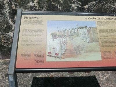
Firepower
Poderío de la artillería
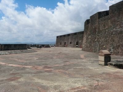
Did Spanish troops ever fire in anger from this deck? In 1797 the British attacked from two miles to the east. Cannon from this battery and those in San Cristobal’s outer defenses shelled the British to keep them from landing east of the San Juan Islet.
This deck, completed around 1790, looked then much as you see it today. It provides excellent view of several garitas (sentry boxes). You can also see here remnants from the Spanish-American War (1898) and World War II (1941-1945)
An officer of the Puerto Rican infantry directs a musket firing drill. This scene would have been common on this level of San Cristobal.
There was not just one national uniform for the Spanish army in the late 1700’s Each of the many regiments that served in Puerto Rico wore distinctive decorations, such as the bright red labels, sleeves, and collars you see on this infantry company.
Poderío de la artillería
En este nivel estaba la batería principal de San Cristóbal. En términos de capacidad de ataque, esta era la mayor de las defensas de la fortificación. Si los atacantes superaban las defensas del extremo este, estos cañones los harían retroceder.
¿Dispararon los españoles alguna vez con furia desde este nivel? En 1797 los británicos atacaron por el este a una distancia de dos millas. Cañones desde esta batería y de las defensas exteriores en San Cristóbal dispararon hacia los británicos evitando su desembarco al este de la isleta del San Juan.
Este nivel, terminado alrededor de 1790, lucía de manera similar a como usted lo puede ver hoy. Hay unas vistas excelentes de algunas garitas (puestos de observación). Además se pueden apreciar remanentes de la Guerra Hispanoamericana (1898) y de la Segunda Guerra Mundial (1941-1945).
Un oficial de una de las compañías de la milicia de infantería de Puerto Rico dirige un ejercicio de fusilería. Esta actividad hubiera sido común en este nivl de San Cristóbal.
Texto traducido por no poder verlo en el rótulo
No había un solo uniforme nacional para el ejército español en la década de 1700. Cada uno de los muchos regimientos que sirvieron en Puerto Rico llevaban decoraciones distintivas, como las etiquetas de color rojo brillante, mangas y cuellos que se ven en esta compañía de infantería.
Topics. This historical marker is listed in this topic list: Forts and Castles. A significant historical year for this entry is 1797.
Location. 18° 28.044′ N, 66° 6.672′ W. Marker is in San Juan in Municipio de San Juan, Puerto Rico. It is in San Cristóbal. Marker is on Bulevar del Valle. Touch for map. Marker is in this post office area: San Juan PR 00901, United States of America. Touch for directions.
Other nearby markers. At least 8 other markers are within walking distance of this marker. In Defense of San Juan / En defenso de San Juan (here, next to this marker); What About Water? / ¿De Dónde Viene el Agua? (here, next to this marker); Three Flags (here, next to this marker); The Heart of San Cristobal (here, next to this marker); National Historic Site (here, next to this marker); Historic San Juan / San Juan Historico (about 300 feet away, measured in a direct line); Escuela José Julián Acosta (about 500 feet away); Casino de Puerto Rico (about 500 feet away). Touch for a list and map of all markers in San Juan.
Credits. This page was last revised on February 16, 2023. It was originally submitted on October 6, 2012, by Don Morfe of Baltimore, Maryland. This page has been viewed 436 times since then and 3 times this year. Photos: 1, 2, 3. submitted on October 6, 2012, by Don Morfe of Baltimore, Maryland. • Bill Pfingsten was the editor who published this page.
Editor’s want-list for this marker. A photo of the full marker. • Can you help?


