Lively in Lancaster County, Virginia — The American South (Mid-Atlantic)
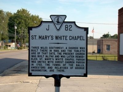
St. Mary’s White Chapel
Erected 1947 by Virginia Conservation Commission. (Marker Number J-82.)
Topics and series. This historical marker is listed in these topic lists: Churches & Religion • Colonial Era. In addition, it is included in the Virginia Department of Historic Resources (DHR) series list. A significant historical year for this entry is 1669.
Location. 37° 46.75′ N, 76° 30.867′ W. Marker is in Lively, Virginia, in Lancaster County. Marker is on Mary Ball Road (Virginia Route 3) just west of White Chapel Road (Virginia Route 201), on the right when traveling east. Touch for map. Marker is in this post office area: Lancaster VA 22503, United States of America. Touch for directions.
Other nearby markers. At least 8 other markers are within 5 miles of this marker, measured as the crow flies. Birthplace of Washington’s Mother (approx. one mile away); World War I Memorial (approx. 2.8 miles away); Veterans Memorial (approx. 2.8 miles away); Confederate Memorial (approx. 2.8 miles away); St. Mary’s Whitechapel (approx. 3.1 miles away); Queenstown (approx. 3.1 miles away); Bewdley (approx. 3.4 miles away); Barford (approx. 4.2 miles away).
Regarding St. Mary’s White Chapel. Turn right at the next intersection (Route 201) to reach St. Mary Whitechapel Church and Cemetery.
St. Mary's White Chapel parish was owned by Major Edward Dale, 1693 and was willed to his two grandsons, Joseph and Peter Carter.(William and Mary's Quarterly, Vol. 17, January 1909, pages 196-202).
Related marker. Click here for another marker that is related to this marker.
Credits. This page was last revised on December 25, 2019. It was originally submitted on November 3, 2009, by J. J. Prats of Powell, Ohio. This page has been viewed 1,574 times since then and 32 times this year. Last updated on October 31, 2012, by Gwynn Nell Swanson of Blanchard, Oklahoma. Photos: 1, 2. submitted on November 3, 2009, by J. J. Prats of Powell, Ohio. • Bill Pfingsten was the editor who published this page.

