Pittsford in Rutland County, Vermont — The American Northeast (New England)
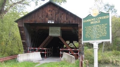
Hammond Covered Bridge
Inscription.
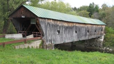
One of four covered bridges in the town of Pittsford, this 139’ Town lattice truss bridge was built in 1842 by Asa Nourse. During the 1927 flood the bridge floated off its abutments and ended up in a field over a mile down stream. During the winter of 1927-28 the town returned the bridge to its former location.
Erected 1991 by Vermont Division for Historic Preservation.
Topics and series. This historical marker is listed in these topic lists: Bridges & Viaducts • Disasters. In addition, it is included in the Covered Bridges series list. A significant historical year for this entry is 1842.
Location. 43° 43.232′ N, 73° 3.244′ W. Marker is in Pittsford, Vermont, in Rutland County. Marker is on Kendall Hill Road, 0.7 miles west of Franklin Street (U.S. 7), on the right when traveling west. Touch for map. Marker is in this post office area: Pittsford VT 05763, United States of America. Touch for directions.
Other nearby markers. At least 8 other markers are within 5 miles of this marker, measured as the crow flies. Pittsford's Iron Industry (approx. 1.6 miles away); Kendrick Dam, Pond, Mill, and Ice House (approx. 1.7 miles away); Fort Vengeance (approx. 1.9 miles away); The Vermont Sanatorium (approx. 2 miles away); Vermont Marble Company (approx. 4.1 miles away); Proctor (VT) War Memorial (approx. 4.2 miles away); John Sunderland (approx. 4.2 miles away); Otter Creek (approx. 4.2 miles away). Touch for a list and map of all markers in Pittsford.
Additional commentary.
1. Tread lightly.
The Hammond Covered Bridge was bypassed in 1960 by a concrete bridge. Modern truck traffic to and from on this road is heavy and the bridge would not be able to handle the abuse. As it is, the bridge has had to undergo a special stabilization process to save it. Vehicular traffic is prohibited, but pedestrians are able to enter.
At the time photograph #2 was taken, there was evidence that the bridge had been threatened by flooding once again. The passage of Hurricane Irene through the area on August 28, 2011 caused severe flooding in the state, claiming one historic covered bridge. Debris caught in the Hammond bridge suggests that waters came up to at least the underside of it.
— Submitted November 26, 2012, by Steve Bergeron of Milton, Vermont.
Credits. This page was last revised on August 24, 2016. It was originally submitted on November 26, 2012, by Steve Bergeron of Milton, Vermont. This page has been viewed 607 times since then and 17 times this year. Photos: 1, 2. submitted on November 26, 2012, by Steve Bergeron of Milton, Vermont. • Bill Pfingsten was the editor who published this page.

