Old Town in Alexandria, Virginia — The American South (Mid-Atlantic)
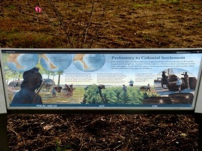
Prehistory to Colonial Settlement
Jones Point Park
— National Park Service, U.S. Department of the Interior —
Attracted to the seasonal resources of the river, woods and marsh made available by the warming climates that followed the last Ice Age, a small group of native peoples left their inland villages in the spring to establish hunting and fishing camps on Jones Point.
European colonists were required to “seat” their land patents by planting tobacco. Stafford County planter John Alexander—an early owner of Jones Point—arranged for tenant farmers (including Charles Jones, for whom Jones Point was named) and crews of enslaved African Americans to work the remote farm.
A Tobacco inspection station established near the foot of what is now Oronoco Street became the genesis of the active town of Alexandria in 1749.
(sidebar)
Ice Age
During the last Ice Age, glaciers locked away massive amounts of seawater in ice. Low sea levels exposed more land and enlarged the footprint of Jones Point.
Post Ice Age
Warming climates melted the glaciers after the last Ice Age. Rising sea levels created a tidally-flooded marsh (pocosin) that separated Jones Point from the mainland.
Historic Period
Sea levels continued to rise, but sedimentation gradually added land to Jones Point. In 1794, Alexandrians reinforced what may have been a slender, natural causeway permanently reconnecting Jones Point to the mainland.
Erected by National Park Service, U.S. Department of the Interior.
Topics. This historical marker is listed in these topic lists: Colonial Era • Native Americans • Settlements & Settlers. A significant historical year for this entry is 1749.
Location. 38° 47.536′ N, 77° 2.547′ W. Marker is in Alexandria, Virginia. It is in Old Town. Marker can be reached from Jones Point Drive, 0.2 miles east of South Royal Street, on the right when traveling east. Marker is located near a playground in Jones Point Park. Touch for map. Marker is in this post office area: Alexandria VA 22314, United States of America. Touch for directions.
Other nearby markers. At least 8 other markers are within walking distance of this marker. The Emerging Nation (here, next to this marker); World Wars to the Present (here, next to this marker); The First People on Jones Point (within shouting distance of this marker); A World War I Shipyard Transforms Jones Point (about 300 feet away,
measured in a direct line); Mount Vernon Trail (about 300 feet away); World War I-Era Rudder (about 300 feet away); Potomac Connections (about 400 feet away); Welcome to Jones Point Park (about 400 feet away). Touch for a list and map of all markers in Alexandria.
Related markers. Click here for a list of markers that are related to this marker. These three markers jointly tell the history of Jones Point.
Credits. This page was last revised on January 28, 2023. It was originally submitted on December 21, 2012, by Allen C. Browne of Silver Spring, Maryland. This page has been viewed 936 times since then and 55 times this year. Photos: 1, 2. submitted on December 21, 2012, by Allen C. Browne of Silver Spring, Maryland. • Bernard Fisher was the editor who published this page.

