Near Dinwiddie in Dinwiddie County, Virginia — The American South (Mid-Atlantic)
Attack on the Angle
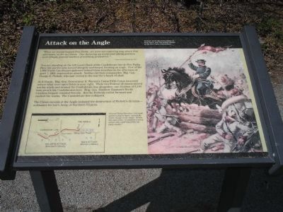
“When we moved toward Five Forks…we were not expecting any attack that afternoon, so far as I know. Our throwing up works and taking position were simply general matters of military precaution.”
- Major General Fitzhugh Lee, CSA
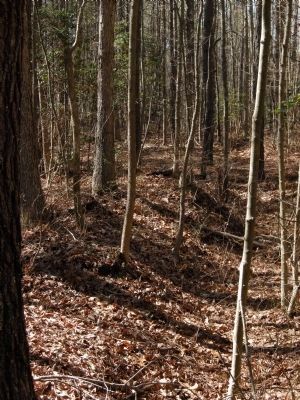
You are standing on the left (east) flank of the Confederate line at Five Forks. Here the earthworks turned abruptly northward, forming an angle. Few of the 1,000 North Carolinians gathered behind these trenches on the afternoon of April 1, 1865, expected an attack. Neither did their commander, Maj. Gen. George E. Pickett, who had retired to the rear for a lunch of shad.
At 4:15 p.m., Maj. Gen. Gouverneur K. Warren’s Union Fifth Corps swarmed across what were open fields to your right. While two Federal divisions moved too far north and missed the Confederate line altogether, one division of 3,100 men struck the Confederates here. Brig. Gen. Matthew Ransom’s North Carolina brigade resisted fiercely. Both the Federals rolled forward and vaulted the works. The Confederate line collapsed.
The Union success at the Angle initiated the destruction of Pickett’s division – a disaster for Lee’s Army of Northern Virginia.
Topics. This historical marker is listed in this topic list: War, US Civil. A significant historical date for this entry is April 1, 1865.
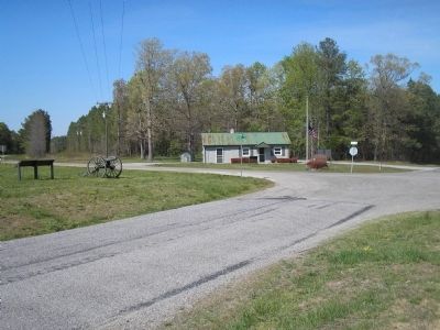
Location. 37° 8.399′ N, 77° 36.663′ W. Marker is near Dinwiddie, Virginia, in Dinwiddie County. Marker is on White Oak Road (Virginia Route 613), on the right when traveling west. Marker is in the Five Forks Unit of Petersburg National Battlefield. Touch for map. Marker is in this post office area: Dinwiddie VA 23841, United States of America. Touch for directions.
Other nearby markers. At least 8 other markers are within walking distance of this marker. "I was exceeding anxious to attack at once…" (approx. half a mile away); Siege of Petersburg — The Linchpin is Pulled (approx. 0.6 miles away); The Siege of Petersburg (approx. 0.6 miles away); "Advanced…repulsed…charged again…" (approx. 0.6 miles away); The Battle of Five Forks (approx. 0.6 miles away); Five Forks Battlefield (approx. 0.7 miles away); a different marker also named Battle of Five Forks (approx. 0.7 miles away); "Hold Five Forks at all hazards…" (approx. 0.7 miles away). Touch for a list and map of all markers in Dinwiddie.
More about this marker. The right portion of this marker features a painting of a mounted Gen. Sheridan leaping over the Confederate earthworks, with the caption General Philip Sheridan - his headquarters flag in hand - joined the Union charge on the Angle. Of him, one man wrote, "It would be a sorry soldier who could help following such a leader."
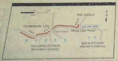
The bottom left of the marker contains a map showing the Confederate fortifications around Five
Forks, and the Union lines of attack. The marker is at the right end of the fortifications, near Warren's main attack.
Also see . . .
1. Five Forks Battlefield. Wikipedia entry (Submitted on January 30, 2024, by Larry Gertner of New York, New York.)
2. Battle of Five Forks (Petersburg National Battlefield). National Park Service website entry (Submitted on January 30, 2024, by Larry Gertner of New York, New York.)
Credits. This page was last revised on January 30, 2024. It was originally submitted on March 15, 2008, by Bill Coughlin of Woodland Park, New Jersey. This page has been viewed 1,535 times since then and 34 times this year. Photos: 1, 2. submitted on March 15, 2008, by Bill Coughlin of Woodland Park, New Jersey. 3. submitted on August 8, 2015, by Brandon Fletcher of Chattanooga, Tennessee. 4, 5. submitted on March 15, 2008, by Bill Coughlin of Woodland Park, New Jersey. 6. submitted on March 28, 2008, by Harold Colson of San Diego, California. • Craig Swain was the editor who published this page.
