Baldwyn in Lee County, Mississippi — The American South (East South Central)
Brice's Cross Roads
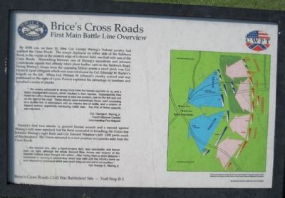
First Main Battle Line Overview
...the enemy advanced in strong force from the woods opposite to us, and a heavy engagement ensued, which resulted in their repulse. Subsequently they made two other desperate attampts to take our position, one on the left and one on the right of the road. these attacks were exceedingly fierce, and consisting of a double line of skirmishers with an infantry line of battle, and a column of support behind, apparently numbering 4,000 men. the first of these assaults was repulsed...
Col. George E. Waring, Jr., Fourth Missouri Cavalry commanding First Brigade
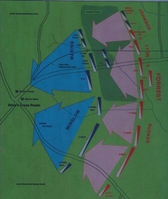
Forrest's first two attacks (a general frontal assault and a second against Waring's left) were repulsed, but his third succeeded in breaching the Union line between Waring's right flank and Col. Edward Winslow's left. (200 yards south of this location.) The Union retreated to a new position one quarter mile from the Cross Roads.
...the second one, after a hand-to-hand fight, was successful, and forced back my right, although the whole Second New Jersey and reserve of the Seventh Indiana were brought into action....After falling back a short distance I succeeded in forming a second line, which was held until the infantry came up and relieved my command which was much fatigued and out of ammunition.
Col. George E. Waring, Jr.
Battle Map Confederate Cavalry converges on Union Cavalry and pushes them towards Brice's Crossroads
Erected by CWPT (Civil War Preservation Trust). (Marker Number B-1.)
Topics. This historical marker is listed in this topic list: War, US Civil. A significant historical month for this entry is June 1950.
Location. 34° 30.421′ N, 88° 43.289′ W. Marker is in Baldwyn, Mississippi, in Lee County. Marker can be reached from Bethany Road (County Road 370) 0.1 miles east of Guntown/Ripley Road (County Road 370), on the left when traveling west. Interpretive tablet is at the eastern end of a walking trail at Stop 5 of the Brice's Crossroads Auto Tour. The walking trail through Porter's Field parallels Bethany Road and is just under 2000 feet long. Touch for map. Marker is in this post office area: Baldwyn MS 38824, United States of America. Touch for directions.
Other nearby markers. At least 8 other markers are within walking distance of this marker. A different marker also named Brice's Cross Roads (about 500 feet away, measured in a direct line); Federal Cavalry and Artillery Formed First Battle Line Here (about 500 feet away); Treaty of Pontotoc (about 600 feet away); Tippah, Tishomingo, Pontotoc, Itawamba Intersection (about 700 feet away); Battle of Brice's Cross Roads, MS (about 700 feet away); Confederate's Second Battle Line (approx. 0.2 miles away); Confederate's First Battle Line Formed Here (approx. ¼ mile away); a different marker also named Brice's Cross Roads (approx. 0.3 miles away). Touch for a list and map of all markers in Baldwyn.
Credits. This page was last revised on June 16, 2016. It was originally submitted on December 27, 2012, by David Graff of Halifax, Nova Scotia. This page has been viewed 719 times since then and 9 times this year. Photos: 1. submitted on December 27, 2012, by David Graff of Halifax, Nova Scotia. 2, 3. submitted on September 25, 2015, by Brandon Fletcher of Chattanooga, Tennessee. 4. submitted on December 27, 2012, by David Graff of Halifax, Nova Scotia. • Craig Swain was the editor who published this page.


