Centreville in Queen Anne's County, Maryland — The American Northeast (Mid-Atlantic)
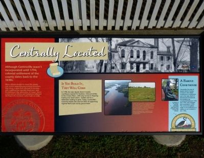
Centrally Located
Although Centreville wasn't incorporated until 1794, colonial settlement of the county dates back to the 1630s.
When officials decided to move the county seat and its supporting government functions, they chose a name that reflected its location and a spelling that signaled American's post Revolutionary War admiration of France. Street names such as Liberty and Commerce reflected the hopes of a newborn nation built on trade.
If You Build It, They Will Come
In 1796, the new Queen Anne's County courthouse opened for business. Close proximity of the Corsica River -- with easy access to shipping, trading and naval waters -- boded well for a settlement looking to grow. Today, Centreville's economy retains the core functions of supporting regional farms and county government.
Famous Courthouse
Centreville, the seat of Queen Anne's County, is home to the oldest courthouse in continuous use in the state. Built of Flemish-bond brickwork, the building was constructed between 1792 and 1796, and enlarged and renovated in 1876. The carved and gilded eagle on the pediment is a replica of the one installed in the 1790s.
Erected by Maryland Heritage Areas Authority.
Topics. This historical marker is listed in these topic lists: Colonial Era • Settlements & Settlers. A significant historical year for this entry is 1794.
Location. 39° 2.62′ N, 76° 3.941′ W. Marker is in Centreville, Maryland, in Queen Anne's County. Marker is on South Commerce Street (Maryland Route 213), on the right when traveling north. The marker is along the fence south of Wright's Chance. Touch for map. Marker is in this post office area: Centreville MD 21617, United States of America. Touch for directions.
Other nearby markers. At least 8 other markers are within walking distance of this marker. Wright's Chance (here, next to this marker); a different marker also named Wright’s Chance (within shouting distance of this marker); William Harper, Sr. Houses (within shouting distance of this marker); Tucker House (within shouting distance of this marker); Site of Goldsborough House (about 400 feet away, measured in a direct line); Centreville National Bank of Maryland (about 400 feet away); The Brass Pin (about 400 feet away); Queen Anne's County Courthouse (about 400 feet away). Touch for a list and map of all markers in Centreville.
Credits. This page was last revised on March 15, 2024. It was originally submitted on January 12, 2013, by Allen C. Browne of Silver Spring, Maryland. This page has been viewed 486 times since then and 6 times this year. Photos: 1, 2. submitted on January 12, 2013, by Allen C. Browne of Silver Spring, Maryland. • Bill Pfingsten was the editor who published this page.

