Middle Branch Park in Baltimore, Maryland — The American Northeast (Mid-Atlantic)
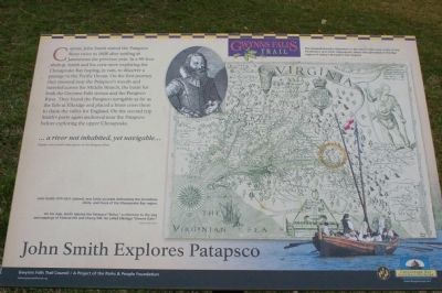
John Smith Explores Patapsco
Erected by Gwynns Falls Trail Council.
Topics and series. This historical marker is listed in these topic lists: Colonial Era • Exploration • Waterways & Vessels. In addition, it is included in the Maryland, Gwynns Falls Trail series list. A significant historical year for this entry is 1608.
Location. 39° 15.313′ N, 76° 36.93′ W. Marker is in Baltimore, Maryland. It is in Middle Branch Park. Marker can be reached from Waterview Avenue. Marker is near the boat ramps. Touch for map. Marker is at or near this postal address: 2801 S Hanover St, Brooklyn MD 21225, United States of America. Touch for directions.
Other nearby markers. At least 8 other markers are within walking distance of this marker. On Guard (within shouting distance of this marker); Maryland Vietnam Veterans Memorial (about 400 feet away, measured in a direct line); Hippocrates' Platanus (Sycamore) (approx. ¼ mile away); Gwynns Falls Trail (approx. 0.3 miles away); Senator Harry McGuirk (approx. 0.3 miles away); A River that Shaped a City (approx. 0.4 miles away); River, Industry, & Community (approx. 0.4 miles away); Restoring Space (approx. 0.4 miles away). Touch for a list and map of all markers in Baltimore.
Also see . . .
1. Image of the marker. (Submitted on March 18, 2008, by Christopher Busta-Peck of Shaker Heights, Ohio.)
2. Gwynns Falls Trail Council. (Submitted on March 18, 2008, by Christopher Busta-Peck of Shaker Heights, Ohio.)
Credits. This page was last revised on April 6, 2023. It was originally submitted on March 18, 2008, by Christopher Busta-Peck of Shaker Heights, Ohio. This page has been viewed 2,079 times since then and 104 times this year. Photos: 1, 2, 3. submitted on March 18, 2008, by Christopher Busta-Peck of Shaker Heights, Ohio.


