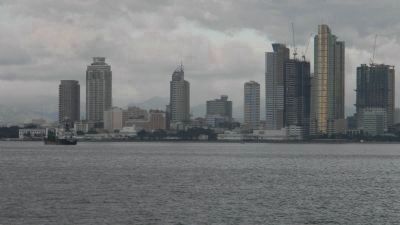
Corregidor Island in Cavite, Calabarzon, Philippines — Southeast Asia
Corregidor
Monument to Peace, Human Valor and International Understanding
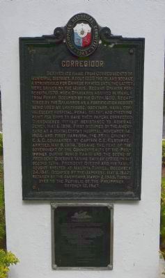
Corregidor derived its name from Corregimiento or “Municipal District”. About 1225 the island became a stronghold for Chinese pirates until the latter were driven by the Moros. Became Spanish possession, 1570, when Spaniards arrived in Manila from Panay. Occupied by the Dutch, 1600. Recaptured by the Spaniards as a fortification besides being used as lighthouse, dockyard, naval convalescent hospital, penal colony, and checking point for ships to have their papers corrected. Surrendered without resistance to Admiral Dewey, May 6, 1898. First occupied by the Americans as a convalescent hospital, November 14, 1904, and first garrison, the 35th Company, C.A.C., commanded by Captain C.E. Kilbourne, arrived, May 8, 1908. Became the seat of the Government of the Commonwealth of the Philippines during World War II and the scene of President Quezon’s taking oath of office on his second term. President Quezon and his family sought shelter at Malinta Tunnel, December 24, 1941. Occupied by the Japanese, May 6, 1942: retaken by the Americans, March 2, 1945. Turned over to the Republic of the Philippines, October 12, 1947.
Through the many eras of its existence, Corregidor has told its story from the mouths of its guns … The last reverberating shots have been fired …
There is left only the memory of countless soldiers who have fought and died on it… The guns will now be forever stilled as the Filipino people pledge that from this day, November 30, 1989 – this shrine so nobly shared by many nations shall be known as
Monument to Peace, Human Valor and International Understanding.
Corregidor Foundation, Inc.
Republic of the Philippines
[List of Foundation Officers: ... illegible]
Erected 1949 by Philippines Historical Committee/1989 Corregidor Foundation, Inc.
Topics. This memorial is listed in these topic lists: Military • Notable Places • War, World II • Waterways & Vessels. A significant historical date for this entry is March 2, 1865.
Location. 14° 23.26′ N, 120° 35.24′ E. Marker is on Corregidor Island, Calabarzon, in Cavite. Tourist access to Corregidor is generally via commercial ferry boats from Manila, and movement between points of interest on the island is mostly aboard open trolley-style tour vans. Touch for map. Touch for directions.
Other nearby markers. At least 8 other markers are within walking distance of this marker. Malinta Tunnel (about 180 meters away, measured in a direct line); General Jonathan M. Wainwright Memorial (approx. 0.2 kilometers away); To the Angels (approx. 0.9 kilometers away); "Tribute to the Brave Heroes" (approx. 1.4 kilometers away); "For the Repose of Souls"
(approx. 1.4 kilometers away); Corregidor Lighthouse (approx. 1.5 kilometers away); Spanish Historical Marker (approx. 1.5 kilometers away); 503rd Airborne- "The Rock Force" -Memorial (approx. 1.6 kilometers away). Touch for a list and map of all markers in Corregidor Island.
Related marker. Click here for another marker that is related to this marker. To better understand the relationship, study each marker in the order shown.
Credits. This page was last revised on February 12, 2022. It was originally submitted on February 24, 2013, by Richard E. Miller of Oxon Hill, Maryland. This page has been viewed 1,189 times since then and 83 times this year. Last updated on March 6, 2013, by Richard E. Miller of Oxon Hill, Maryland. Photos: 1, 2, 3. submitted on February 24, 2013, by Richard E. Miller of Oxon Hill, Maryland. 4, 5. submitted on March 3, 2013, by Richard E. Miller of Oxon Hill, Maryland. • Bill Pfingsten was the editor who published this page.
