Pinckney in Lawrence in Douglas County, Kansas — The American Midwest (Upper Plains)
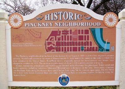
Historic Pinckney Neighborhood
The Pinckney neighborhood at the bend of the Kansas River began in 1854 as part of the original Lawrence townsite. North/South streets to the west of Massachusetts St. were named for states in the order in which they were admitted to the United States. East/West streets, originally named for Revolutionary war heroes, were changed to numbers in 1913. The modern neighborhood of about 1,200 residents extends to Iowa St.
Homes, businesses, a brickyard, and brewery were located in the Pinckney Neighborhood. Today social and health agencies, including Lawrence Memorial Hospital mix with homes in the area. Three parks, Constant and Burcham Parks along the Kansas River and Cinton Park along 5th St., provide open space. The trail head for a river walk leaves Constant Park and links to Burcham Park to welcome visitors for hiking along the Kansas River.
1858 Pinckney Neighborhood
Pinckney Street renamed 6th Street in 1913.
Topics. This historical marker is listed in this topic list: Settlements & Settlers. A significant historical year for this entry is 1854.
Location. 38° 58.402′ N, 95° 14.357′ W. Marker is in Lawrence, Kansas, in Douglas County. It is in Pinckney. Marker is at the intersection of 6th Street (U.S. 40/59) and Tennessee Street, on the right when traveling west on 6th Street . Touch for map. Marker is in this post office area: Lawrence KS 66044, United States of America. Touch for directions.
Other nearby markers. At least 8 other markers are within walking distance of this marker. Lawrence (a few steps from this marker); Santa Fe Steam Locomotive 1073 (about 400 feet away, measured in a direct line); Buford M. Watson Jr. Park (about 600 feet away); John Brown and the Siege of Lawrence, September 14-15, 1856 (approx. ¼ mile away); Free State Hotel (approx. ¼ mile away); Liberty Hall (approx. ¼ mile away); 700-702 Massachusetts Street (approx. ¼ mile away); Anderson Building (approx. ¼ mile away). Touch for a list and map of all markers in Lawrence.
Also see . . .
1. Cordley's A History of Lawrence, Kansas (1895). (Submitted on March 24, 2013, by William Fischer, Jr. of Scranton, Pennsylvania.)
2. City of Lawrence, Kansas, Official Site. (Submitted on March 24, 2013, by William Fischer, Jr. of Scranton, Pennsylvania.)
Credits. This page was last revised on February 10, 2023. It was originally submitted on March 24, 2013, by William Fischer, Jr. of Scranton, Pennsylvania. This page has been viewed 542 times since then and 29 times this year. Photos: 1, 2. submitted on March 24, 2013, by William Fischer, Jr. of Scranton, Pennsylvania.

