Eufaula in McIntosh County, Oklahoma — The American South (West South Central)
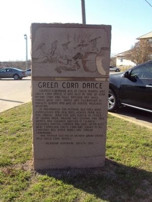
Green Corn Dance
In preparation for festival old fires were extinguished and new ones lighted from old fire embers. Main fire was placed in center of square area. Around this central fire men, women, and children, dressed in colorful costumes, danced, chanted, and sang. After rites were completed, green corn was served to all. Choctaws and other tribes had similar ceremonies.
This marker erected in vicinity of where Creeks held Corn Dances.
Erected 1966 by Oklahoma Historical Society.
Topics and series. This historical marker is listed in this topic list: Native Americans. In addition, it is included in the Oklahoma Historical Society series list.
Location. 35° 16.958′ N, 95° 35.484′ W. Marker is in Eufaula, Oklahoma, in McIntosh County. Marker is on Forest Avenue west of South 6th Street when traveling west. Located in the parking lot of the Choctaw Nation Health Clinic. Touch for map. Marker is at or near this postal address: 800 W Forrest Ave, Eufaula OK 74432, United States of America. Touch for directions.
Other nearby markers. At least 8 other markers are within 14 miles of this marker, measured as the crow flies. Veterans Memorial (approx. half a mile away); Alexander Posey (approx. half a mile away); Mr. and Mrs. T.H. Palmer (approx. 0.6 miles away); City Hall (approx. 0.7 miles away); Buckner Cemetery (approx. 0.9 miles away); Asbury Memorial (approx. 0.9 miles away); Missouri-Kansas-Texas Depot (approx. 13.4 miles away); Paul Henry Carr (approx. 13.4 miles away). Touch for a list and map of all markers in Eufaula.
Credits. This page was last revised on June 16, 2016. It was originally submitted on April 5, 2013, by Michael Manning of Woodlawn, Tennessee. This page has been viewed 588 times since then and 23 times this year. Photo 1. submitted on April 5, 2013, by Michael Manning of Woodlawn, Tennessee. • Bernard Fisher was the editor who published this page.
Editor’s want-list for this marker. Wide shot of marker and its surroundings. • Can you help?
