Near Sharpsburg in Washington County, Maryland — The American Northeast (Mid-Atlantic)
Ninth Army Corps
Ninth Army Corps.
Brig. Gen. Jacob D. Cox, Commanding.
September 17, 1862.
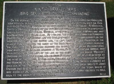
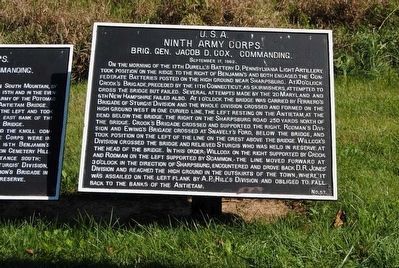
On the morning of the 17th, Durell's Battery D, Pennsylvania Light Artillery took position on the ridge to the right of Benjamin's and both engaged the Confederate Batteries posted on the high ground near Sharpsburg. At 10 o'clock Crook's Brigade preceded by the 11th Connecticut, as skirmishers, attepmted to cross the bridge but failed. Several attempts made by the 2d Maryland and 6th New Hampshire failed also. At 1 o'clock the bridge was carried by Ferrero's Brigade of Sturgis' Division and the whole division crossed and formed on the high ground west in one curved line, the left resting on the Antietam at the bend below the bridge, the right on the Sharpsburg road 250 yards north of the bridge. Crook's Brigade crossed and supported the right. Rodman's Division and Ewing's Brigade crossed at Snavely's Ford, below the bridge, and took position on the left of the line on the crest above the bridge. Willcox's Division crossed the bridge and relieved Sturgis who was held in reserve at the head of the bridge. In this order, Wilcox on the right supported by Crook and Rodman on the left supported by Scammon, the line moved forward at 3 o'clock in the direction of Sharpsburg, encountered and drove back D.R. Jones' Division and reached the high ground in the outskirts of the town, where it was assailed on the left flank by A.P. Hill's Division and obliged to fall back to the banks of the Antietam.
Erected by Antietam Battlefield Board. (Marker Number 57.)
Topics and series. This historical marker is listed in this topic list: War, US Civil. In addition, it is included in the Antietam Campaign War Department Markers series list. A significant historical month for this entry is September 1889.
Location. 39° 27.033′ N, 77° 43.879′ W. Marker is near Sharpsburg, Maryland, in Washington County. Marker can be reached from Old Burnside Bridge Road, on the left when traveling east. Located to the east of stop 9 (Burnside Bridge) of the driving tour of Antietam Battlefield, in a tablet cluster along the walking trail east of the bridge. Touch for map. Marker is in this post office area: Sharpsburg MD 21782, United States of America. Touch for directions.
Other nearby markers. At least 8 other markers are within walking distance of this marker. Fifty-First New York Infantry (here, next to this marker); a different marker also named Ninth Army Corps (here, next to this marker); Sturgis's Division, Ninth Army Corps (here, next to this marker); a different marker also named Ninth Army Corps (here, next to this marker); Witness to History (here, next to this marker); 51st Pennsylvania Volunteer Infantry (a few steps from this marker); 2nd Maryland Infantry (within shouting distance of this marker); "Will You Give Us Our Whiskey?" (within shouting distance of this marker). Touch for a list and map of all markers in Sharpsburg.
Also see . . .
1. Antietam Battlefield. National Park Service site. (Submitted on March 22, 2008, by Craig Swain of Leesburg, Virginia.)
2. Ninth Army Corps. Brig. Gen. Cox, temporarily commanding the corps while Maj. Gen. Burnside commanded the 'Left Wing' of the army, was a politically appointed general. He would serve after the war as Governor of Ohio and Secretary of the Interior in the Grant administration. (Submitted on March 22, 2008, by Craig Swain of Leesburg, Virginia.)
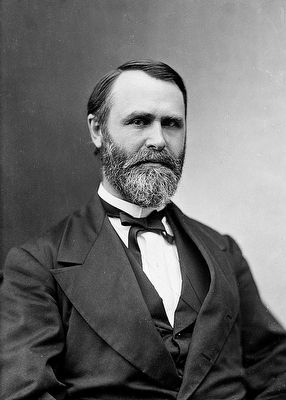
3. Jacob Dolson Cox. Jacob Dolson Cox, (Jr.) (October 27, 1828 – August 4, 1900) was a lawyer, a Union Army general during the American Civil War, and later a Republican politician from Ohio. He served as the 28th Governor of Ohio and as United States Secretary of the Interior. (Submitted on September 30, 2015, by Brian Scott of Anderson, South Carolina.)
Photographed By Craig Swain
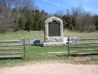
3. Monument and Tablet Cluster on East End of Burnside Bridge
From left to right are the Ninth Army Corps Tablet for September 15-16 (Number 56), Ninth Army Corps Tablet for 17 September (Number 57), The 51st New York Monument, Sturgis' Division (Number 58), and Ferrero's Brigade Tablet (Number 68)
Photographed By Matthew Brady, LOC
4. Jacob Dolson Cox, Jr. (1824-1900)
When corps commander Maj. Gen. Jesse L. Reno was killed at the Battle of South Mountain, Cox assumed command of the IX Corps. He suggested to Maj. Gen. Ambrose Burnside, formally the commander of IX Corps, but who was commanding a two-corps "wing" of the Army, that he be allowed to return to division command, which was more in keeping with his level of military expertise. Burnside refused the suggestion, but kept Cox under his supervision at the Battle of Antietam.
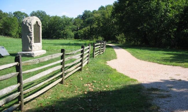
Photographed By Craig Swain, September 17, 2007
5. Approaches to the Burnside Bridge
Through the morning, on this ground on the east side of the Burnside Bridge, in front of the tablet cluster and the 51st New York Monument (on the left) the IX Corps fought to attain a foot hold to support a crossing of Antietam Creek. Forced into a very confined space, the Corps found its way blocked by a handful of Confederates on high ground on the west side.
Credits. This page was last revised on November 24, 2017. It was originally submitted on March 22, 2008, by Craig Swain of Leesburg, Virginia. This page has been viewed 818 times since then and 14 times this year. Photos: 1. submitted on March 22, 2008, by Craig Swain of Leesburg, Virginia. 2. submitted on September 30, 2015, by Brian Scott of Anderson, South Carolina. 3. submitted on April 1, 2008, by Craig Swain of Leesburg, Virginia. 4. submitted on September 30, 2015, by Brian Scott of Anderson, South Carolina. 5. submitted on March 22, 2008, by Craig Swain of Leesburg, Virginia.
