Crisfield in Somerset County, Maryland — The American Northeast (Mid-Atlantic)
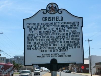
Crisfield
Erected by Maryland Historical Trust, Maryland State Highway Administration.
Topics. This historical marker is listed in these topic lists: Industry & Commerce • Settlements & Settlers. A significant historical year for this entry is 1854.
Location. 37° 58.75′ N, 75° 51.617′ W. Marker is in Crisfield, Maryland, in Somerset County. Marker is at the intersection of West Main Street and 9th Street on West Main Street. Touch for map. Marker is in this post office area: Crisfield MD 21817, United States of America. Touch for directions.
Other nearby markers. At least 8 other markers are within 4 miles of this marker, measured as the crow flies. The Evolving Crisfield Harbor (approx. ¼ mile away); Commerce on the Water (approx. ¼ mile away); J. Millard Tawes (approx. 0.4 miles away); 'Spirit Of The American Doughboy' (approx. 0.9 miles away); The J. Millard Tawes Homeplace (approx. one mile away); Make Peace (approx. 1.6 miles away); Searching for Water (approx. 2.3 miles away); Ye Old St. Peters Methodist Church (approx. 3.4 miles away). Touch for a list and map of all markers in Crisfield.
Credits. This page was last revised on June 16, 2016. It was originally submitted on July 8, 2013, by Don Morfe of Baltimore, Maryland. This page has been viewed 533 times since then and 32 times this year. Photos: 1, 2. submitted on July 8, 2013, by Don Morfe of Baltimore, Maryland. • Bill Pfingsten was the editor who published this page.

