Near Bethany in Harrison County, Missouri — The American Midwest (Upper Plains)
Harrison County
[Front]
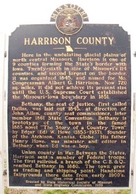
Here in the undulating glacial plains of north central Missouri, Harrison is one of 9 counties forming the State's border with Iowa. Twenty-sixth in size of Missouri's 114 counties, and second largest on the border, it was organized 1845, and named for Mo. Congressman Albert G. Harrison. Now 720 sq. miles, it did not achieve its present size until the U.S. Supreme Court established the Missouri-Iowa boundary in 1851.
Bethany, the seat of justice, first called Dallas, was laid out 1845, at direction of John Allen, county seat commissioner, later member 1861 State Convention. Bethany is prototype of the town in the famed 1883 novel "The Story of a Country Town" by Edgar (Ed) W. Howe (1853-1937), founder of the Atchison, Kansas, Globe. His father Henry Howe, was minister and editor in Bethany when Ed was a boy.
Union county in War Between the States, Harrison sent a number of Federal troops. The first railroad, a branch of the C. B. & Q., reach Bethany in 1880. The town grew as trading and shipping point. Handsome fairgrounds there date from early 1900's.
(See other side)
[Back]
(Continued from other side)
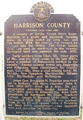
A county of fertile Grand River basin, Harrison is a grain and livestock farming area. In region ceded by Iowa, Sac, and Fox tribes, 1824, the county was roamed by Indians into the 1840's. The Great Indian Trail ran east to northwest in the county. Surveyed land was entered for sale, 1842.
Early settlers from Ohio, Ill., other parts of Mo., and the East, came in the late 1830's. Later a number of Bohemians settled in the county. Among county towns are Eagleville and Ridgeway, once contestants for county seat; Cainsville, once a coal mining town; Mt. Moriah; New Hampton; Martinsville; Gilman City; Blythedale; and Melbourne.
Union Gen. Benjamin N. Prentiss practiced law in Bethany and there educator John R. Kirk (1851-1937) lived as a boy. He and progressive education leader Eugene Fair (1877-1937), born in Gilman City, were both presidents of Northeast Mo. State Teachers College. Joseph H. Burrows (1840-1918), who introduced first bill (1881) to cut postage from 3˘ to 2˘ and named John J. Pershing for West Point appointment, was business man and minister in Cainsville.
Erected 1959 by State Historical Society of Missouri and State Highway Commission.
Topics and series. This historical marker is listed in these topic lists: Agriculture • Native Americans • Settlements & Settlers • War, US Civil. In addition, it is included in the Missouri, The State Historical Society of series list. A significant historical year for this entry is 1845.
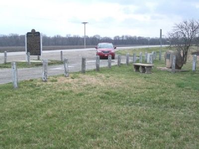
Location. 40° 14.863′ N, 94° 3.656′ W. Marker is near Bethany, Missouri, in Harrison County. Marker is at the intersection of U.S. 136 and 192nd Avenue, on the right when traveling west on U.S. 136. Marker is at a roadside pullout. Touch for map. Marker is in this post office area: Bethany MO 64424, United States of America. Touch for directions.
Other nearby markers. At least 5 other markers are within 3 miles of this marker, measured as the crow flies. Harrison County Court (a few steps from this marker); General Benjamin M. Prentiss Memorial Park (approx. 1.7 miles away); Last of the American Doughboys / Harrison County Veterans Memorial (approx. 2 miles away); Home of Babe Adams (approx. 2 miles away); Bethany Veterans' Memorial (approx. 2.1 miles away).
Credits. This page was last revised on February 11, 2021. It was originally submitted on July 9, 2013, by William Fischer, Jr. of Scranton, Pennsylvania. This page has been viewed 849 times since then and 114 times this year. Photos: 1, 2, 3. submitted on July 9, 2013, by William Fischer, Jr. of Scranton, Pennsylvania.


