Near Canehill in Washington County, Arkansas — The American South (West South Central)
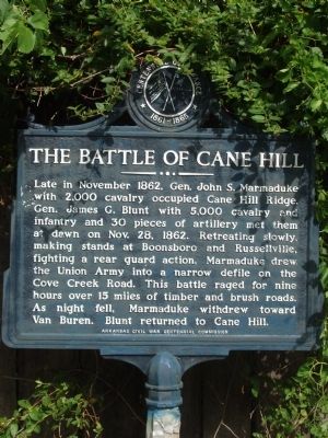
The Battle of Cane Hill
Erected by Arkansas Civil War Centennial Commission.
Topics and series. This historical marker is listed in this topic list: War, US Civil. In addition, it is included in the Arkansas Centennial Commission series list. A significant historical month for this entry is November 1862.
Location. 35° 54.533′ N, 94° 23.787′ W. Marker is near Canehill, Arkansas, in Washington County. Marker is on State Highway 45 just north of Patterson Road. Touch for map. Marker is at or near this postal address: 14327 State Hwy 45, Canehill AR 72717, United States of America. Touch for directions.
Other nearby markers. At least 8 other markers are within 5 miles of this marker, measured as the crow flies. Zebulon and Eunice Edmiston House – 1872 (within shouting distance of this marker); Dr. William and Laura Welch House - 1855 (about 500 feet away, measured in a direct line); Fruit Cellar (about 700 feet away); Washington County Cane Hill College (about 800 feet away); Confederates Fall Back Before Union Assault (approx. 0.2 miles away); The Troops Who Fought at Cane Hill (approx. 0.2 miles away); Bethlehem Cemetery (approx. 4˝ miles away); Bethlehem Methodist-Episcopal Church South (approx. 4˝ miles away). Touch for a list and map of all markers in Canehill.
Also see . . . Battle of Cane Hill - Wikipedia. (Submitted on July 19, 2013, by Bill Pfingsten of Bel Air, Maryland.)
Credits. This page was last revised on March 3, 2024. It was originally submitted on July 13, 2013, by Robert Macoubrie of Lenexa, Kansas. This page has been viewed 1,036 times since then and 48 times this year. Last updated on January 31, 2024, by Jason Armstrong of Talihina, Oklahoma. Photos: 1. submitted on July 13, 2013, by Robert Macoubrie of Lenexa, Kansas. 2, 3. submitted on January 3, 2021, by Allen C. Browne of Silver Spring, Maryland. • Devry Becker Jones was the editor who published this page.
Editor’s want-list for this marker. A photo of the marker and the surrounding area in context. • Can you help?


