Buckingham in Buckingham County, Virginia — The American South (Mid-Atlantic)
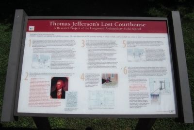
Thomas Jefferson's Lost Courthouse
A Research Project of the Longwood Archaeology Field School
Inscription.
“Buckingham County, 26th February, 1869
A Editor’s dispatch: sad calamity has befallen our country. The court-house was set fire yesterday morning at about 1 o’clock, and by daylight was a mass of ruins.” Source: Richmond Times-Dispatch March 2, 1869
1
With the burning and complete destruction of the courthouse on February 25, 1869 the people of Buckingham County, Virginia, experienced a profound and far-reaching loss. All deeds and public records dating from the County’s founding in 1761 were kept in the Clerk’s offices that were located in the courthouse; thus the entire written heritage of the first 108 years of the county was lost. This same event destroyed one of only two courthouses designed by Thomas Jefferson.
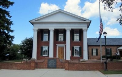
In 2003 and 2004, the Longwood Archaeology Field School, under the direction of Dr. Brian Bates, undertook a research project to determine if anything remained from Thomas Jefferson’s courthouse at Buckingham. If any evidence of that earlier courthouse was found, it would be used to interpret what the Jefferson courthouse looked like as compared to the present courthouse, which was built in 1873. This research was undertaken just prior to the commencement of the renovation and expansion project that resulted in the current courthouse complex.
The plan map to the left shows the courthouse grounds before the renovation and expansion project. As a result of that work, the Commonwealth’s Attorney building was demolished, and all sidewalks were removed. A star marks the place where you are standing.
2
Thomas Jefferson was contacted by his friend Colonel Charles Yancey of Buckingham, who had been appointed to a commission to build a new courthouse for the superior and county courts.
“Buckingham July 12th 1821
My dear Sir,
The Court of this County have ordered the building of a New Court house, and appointed myself and others to draft a plan of the house and let the building of it; I am fully impressed with the importance of good plan & very sensible of my incompetency to draft one; and believing that you have devoted much of your valuable time and reflection to subjects of architecture, I have taken the liberty to trespass upon your time and talents (a common stock) which we all seem to have a right to draw upon, growing out of a long and useful life devoted to both publik and private good, to draft for us a plan of our Court house, as much in detail as will comport with your convenience which will be thankfully viewed and I have no doubt will be adopted by all the Commissioners, and myself and many other of your friends be afforded the opportunity of saying we have built upon
a plan presented by Mr. Jefferson…”
(caption)
Actual letter from Yancy to Jefferson Source: Jefferson Digital Archive University of Virginia
3
An examination of the correspondence between Jefferson and Yancey as well as other archival resources, such as newspaper accounts of the fire, provided a great deal of insight about the design of the courthouse; however, many questions were still unanswered. The Buckingham Courthouse Archaeological Project was designed to address the following research goals:
1) Determine the presence of any evidence of the 1822 Jefferson Courthouse on the grounds of the present (1873) courthouse;
2) Determine the relationship between any evidence found and the current courthouse as a means of identifying whether the 1873 courthouse actually reflected the dimensions of the 1822 Jefferson design;
3) Determine the presence of any evidence supporting construction of the wings or pavilions as proposed by the commissioners;
4) Determine the layout of the portico (piazzar) in view of the presence of six column bases rather than the four originally specified by Jefferson; and
5) Determine the overall dimensions of the 1822 Jefferson courthouse, including the portico (piazzar) and pavilions, if present.
4
A ground-penetrating radar survey (GPR) was conducted by NAEVA Geophysics, Inc. to determine the presence of any subsurface features. The survey produced mixed results; however, the area around 50 North and 70 East had anomalies that were of interest.
(captions)
Ground-penetrating radar (GPR) being used along the west wall of the courthouse.
Plot of the GPR survey. The small circles indicate areas of interest.
5
Based upon the archival records and the GPR survey, it was decided that a number of units would be placed on the western, eastern, and southern sides of the courthouse. Modern improvements, such as landscaping and concrete sidewalks, hampered the complete examination of certain areas of the courthouse green.
The west side of the courthouse was examined first (units 1-5). The results of these units were used to fine-tune the methods and resulted in the opening of one larger unit (unit 7) and two smaller units (units 6 & 8) on the east side of the courthouse. The units to the south of the courthouse (units 9-14) were placed to address the questions relating to the portico and the lesser colonnade.
6
Units 1, 2, 4, & 5 produced evidence of a shallow builder’s trench located 7’10” to the west of the present courthouse wall. The builder’s trench extended west under a sidewalk and, in unit 5, turned and ran parallel to the trench unearthed in unit 2. The placement of two shovel test pits in the speculated location of the southwest corner of the builder’s trench confirmed its presence. Thus these units produced evidence of a builder’s trench measuring 16’3” by 16’5” with the near wall of the small structure being located 7’10” to the west of the courthouse.
This evidence meshed well with the letter from Yancey to Jefferson dated July 4, 1822 wherein Yancey wrote:
“…we have directed a wing on each side, of 16 feet sqr. Attached to the main buiding by an entry of eight feet with an arch on each side, flat roof & columns to the wings…”
The proximity of the builder’s trenches of the wing or pavilion almost exactly 8 feet to the west of the present (1873) courthouse clearly indicated that the western wall of the 1873 courthouse was placed in the same location as that of the 1822 Jefferson courthouse. Unit 3 confirmed that the 1873 courthouse was built on the remains of the foundation of the Jefferson courthouse.
Erected by Virginia Department of Historic Resources.
Topics and series. This historical marker is listed in these topic lists: Architecture • Government & Politics. In addition, it is included in the Former U.S. Presidents: #03 Thomas Jefferson series list. A significant historical date for this entry is February 26, 1869.
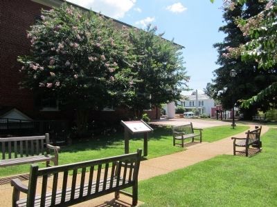
Location. 37° 33.046′ N, 78° 33.404′ W. Marker is in Buckingham, Virginia, in Buckingham County. Marker can be reached from the intersection of West James Anderson Highway (U.S. 60) and Courthouse Road, on the right when traveling west. Touch for map. Marker is at or near this postal address: 13061 W James Anderson Hwy, Buckingham VA 23921, United States of America. Touch for directions.
Other nearby markers. At least 8 other markers are within 2 miles of this marker, measured as the crow flies. A different marker also named Thomas Jefferson’s Lost Courthouse (a few steps from this marker); Buckingham County War Memorial (within shouting distance of this marker); a different marker also named Thomas Jefferson’s Lost Courthouse (within shouting distance of this marker); Confederate Soldiers of Buckingham County (within shouting distance of this marker); Buckingham Courthouse (approx. 0.3 miles away); a different marker also named Buckingham Courthouse (approx. one mile away); After Appomattox (approx. 1.8 miles away); One-Room Schoolhouse (approx. 1.8 miles away). Touch for a list and map of all markers in Buckingham.
Also see . . . Digging for Jefferson's Lost Courthouse. Smithsonian magazine, October 2004 (Submitted on August 5, 2013.)
Credits. This page was last revised on August 6, 2020. It was originally submitted on August 5, 2013, by Bernard Fisher of Richmond, Virginia. This page has been viewed 594 times since then and 27 times this year. Photos: 1, 2, 3. submitted on August 5, 2013, by Bernard Fisher of Richmond, Virginia.


