Ottawa in Franklin County, Kansas — The American Midwest (Upper Plains)
Main Street, 400 Block South
Historic Ottawa Tour Stop 6
Location, location, location
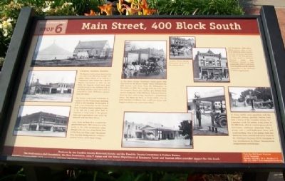
The Baptists built a stone church on the east side of the 400 block in 1867. The photo above shows it as well as a "tabernacle" tent erected for a Kansas Baptist Convention in 1869. By the 1890s, the Baptists would move their church around to the northeast side of the block, and the corner lots would be occupied by John Halloran's lumber yard, left photo.
The lumber yard would eventually be replaced by the Professional Building, which is still standing. At one point, it held a car dealership on the second floor. Would-be buyers wanting to take a car out for a test drive had to negotiate a steep ramp to the ground floor and a precipitous exit across the sidewalk and onto Main Street.
Later, Pence & Bales IGA occupied the ground floor space. This corner was as far south as the 1951 floodwaters came, though water also rose along Skunk Run in City Park, one block south. The second floor was then being used as a women's clothing factory called Mode O'Day.
In this photo, George Washburn's family poses with their float for the Flower Parade which welcomed the 20th Kansas unit home from the Philippines in November of 1899. The carriage held his wife Alice and daughter Hazel, plus another girl. Behind them are two landmarks of the 400 block, Solomon Hester's Hotel de Hoss and George Washburn's architectural office. The Hotel de Hoss, or livery stable, was an early business in Ottawa. One could rent horses and buggies or board one's own horses there.
[Inset photo caption reads] Another Flower Parade float poses in front of the Hotel de Hoss.
G.P. Washburn's 1889 office, which survives today, is seen in an engraving from Corwin's Souvenir of Ottawa and in the far right of the float pictures. No one loved a patriotic occasion better than Washburn, himself a state commander of the Grand Army of the Republic and the national commander of the Survivors of Shiloh organization.
As livery stables were identified with the nineteenth century, gasoline stations have been a fixture of the twentieth century. A.C. Carpenter's Lesh Oil station, in the center of the 400 block, offered a sunken grease pit for lubrication, antifreeze dispensed from a pump, and a well-landscaped stone and wood building. One of the pumps from this station has been restored and can be found at the Old Depot Museum, 135 W. Tecumseh. It was manufactured by Ottawa Manufacturing using recycled oil field pipe.
Visit the Old Depot Museum
135 W. Tecumseh
Tuesday-Saturday 10-4 • Sunday 1-4
785.242.1250 • www.olddepotmuseum.org
Erected by Franklin County Historical Society, Franklin County Convention
& Visitors Bureau, and Others.
Topics. This historical marker is listed in these topic lists: Churches & Religion • Industry & Commerce • Roads & Vehicles • Settlements & Settlers. A significant historical month for this entry is November 1899.
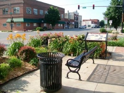
Location. 38° 36.784′ N, 95° 16.126′ W. Marker is in Ottawa, Kansas, in Franklin County. Marker is at the intersection of Main Street and 4th Street, on the right when traveling south on Main Street. Touch for map. Marker is at or near this postal address: 334 South Main Street, Ottawa KS 66067, United States of America. Touch for directions.
Other nearby markers. At least 8 other markers are within walking distance of this marker. The Franklin County Courthouse (within shouting distance of this marker); a different marker also named Franklin County Courthouse (about 400 feet away, measured in a direct line); Main Street, 500 Block South and City Park (about 500 feet away); Civil War Memorial (about 700 feet away); The Down Town Ottawa Historic District (about 800 feet away); Pickrell Building (approx. 0.2 miles away); Ottawa Carnegie Library (approx. 0.2 miles away); Shepherd & McQuesten Building (approx. 0.2 miles away). Touch for a list and map of all markers in Ottawa.
Also see . . .
1. Visit Ottawa, Kansas. City website homepage (Submitted on August 13, 2013, by William Fischer, Jr. of Scranton, Pennsylvania.)
2. Franklin County, Kansas. County website homepage (Submitted on August 13, 2013, by William Fischer, Jr. of Scranton, Pennsylvania.)
3. George P. Washburn. Kansapedia website entry (Submitted on August 13, 2013, by William Fischer, Jr. of Scranton, Pennsylvania.)
Credits. This page was last revised on January 26, 2022. It was originally submitted on August 13, 2013, by William Fischer, Jr. of Scranton, Pennsylvania. This page has been viewed 478 times since then and 18 times this year. Photos: 1, 2. submitted on August 13, 2013, by William Fischer, Jr. of Scranton, Pennsylvania.

