Marker Logo HMdb.org THE HISTORICAL
MARKER DATABASE
“Bite-Size Bits of Local, National, and Global History”
Near Coalville in Summit County, Utah — The American Mountains (Southwest)
 

Wanship Station


Wanship Station Marker image. Click for full size.
Photographed By Duane Hall, July 6, 2013
1. Wanship Station Marker
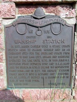
Inscription. In 1861, Aaron Daniels built a stage coach station here to change horses and as an overnight stop for the Overland coach from the east to Salt Lake City. Gilmer and Salsbury operated the line until 1870. In 1869, Kimball Brothers, stage between Echo and S.L.C. also used the station. In 1870, it became the Moorehouse family home; and in 1877, the Andrew Peterson family made it into a rooming and boarding house. Later, it served as a grainary and in 1912, it was torn down.
 
Erected 1951 by Daughters of Utah Pioneers. (Marker Number 165.)
 
Topics and series. This historical marker is listed in this topic list: Roads & Vehicles. In addition, it is included in the Daughters of Utah Pioneers series list. A significant historical year for this entry is 1861.
 
Location. 40° 49.053′ N, 111° 24.098′ W. Marker is near Coalville, Utah, in Summit County. Marker is on Hoytsville Road, 0.3 miles north of Old Lincoln Highway, on the left when traveling north. Touch for map. Marker is in this post office area: Coalville UT 84017, United States of America. Touch for directions.
 
Other nearby markers. At least 7 other markers are within 15 miles of this marker, measured as the crow flies. Old Fort and Hoyt Grist Mill (approx. 4.1 miles away); Old Rock School House (approx. 6.7 miles away); The Founding of Coalville City
Paid Advertisement
Click on the ad for more information.
Please report objectionable advertising to the Editor.
Click or scan to see
this page online
(approx. 6.9 miles away); The Road to Zion (approx. 11.9 miles away); Echo Canyon (approx. 11.9 miles away); Welcome to Echo Canyon (approx. 12 miles away); "Mormon" Pioneer Trail (approx. 14.8 miles away).
 
Wanship Station Marker image. Click for full size.
Photographed By Duane Hall, July 6, 2013
2. Wanship Station Marker
Wanship Station Marker image. Click for full size.
Photographed By Duane Hall, July 6, 2013
3. Wanship Station Marker
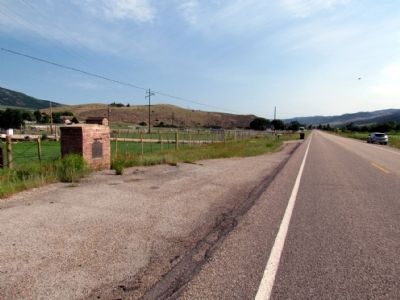
View to north along Hoytsville Road
 
 
Credits. This page was last revised on June 16, 2016. It was originally submitted on August 13, 2013, by Duane Hall of Abilene, Texas. This page has been viewed 723 times since then and 37 times this year. Photos:   1, 2, 3. submitted on August 13, 2013, by Duane Hall of Abilene, Texas.
Share this page.  
Share on Tumblr
m=67622

CeraNet Cloud Computing sponsors the Historical Marker Database.
This website earns income from purchases you make after using our links to Amazon.com. We appreciate your support.
Paid Advertisement
Apr. 25, 2024