Near Cedar City in Iron County, Utah — The American Mountains (Southwest)
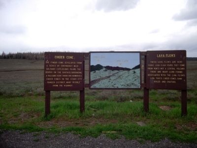
Cinder Cone - Lava Flows
Cinder Cone
The cinder cone developed from a series of continuous mild volcanic explosions piling the debris on the surface surronding a volcanic vent. There are numerous cinder cones on the Cedar City Ranger District, many visible from the highway.
Lava Flows
These lava flows are very young 1,000-5,000 years. They come from vents not a central volcano. There are many land forms associated with the lava flows: lava tubes, cinder cones, sink holes and craters.
Topics. This historical marker is listed in this topic list: Natural Features.
Location. 37° 33.801′ N, 112° 47.347′ W. Marker is near Cedar City, Utah, in Iron County. Marker is on Utah Route 14, 0.2 miles north of Forest Service Road 055, on the right when traveling north. Touch for map. Marker is in this post office area: Brian Head UT 84719, United States of America. Touch for directions.
Other nearby markers. At least 3 other markers are within 8 miles of this marker, measured as the crow flies. A Lasting Legacy (approx. 4˝ miles away); Listen! Can You Hear the Echoes? (approx. 6.9 miles away); Ashdown Gorge Wilderness (approx. 7.4 miles away).
Credits. This page was last revised on June 16, 2016. It was originally submitted on September 21, 2013, by Duane Hall of Abilene, Texas. This page has been viewed 741 times since then and 38 times this year. Photos: 1, 2, 3. submitted on September 21, 2013, by Duane Hall of Abilene, Texas.


