Arco in Butte County, Idaho — The American West (Mountains)
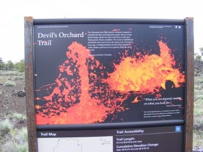
Devil's Orchard Trail
Craters of the Moon National Monument
"What you see depends mainly on what you are looking for." –Richard J. Vogl, biologist.
The trail through this place is as unusual as its name. Rather than identify objects the exhibits here challenges you to think about ideas, concerns, and possible solutions.
Erected by National Park Service-United States Department of the Interior.
Topics. This historical marker is listed in this topic list: Environment.
Location. 43° 27.089′ N, 113° 32.314′ W. Marker is in Arco, Idaho, in Butte County. Marker is on Loop Road. This marker is located on the grounds of the Craters of the Moon National Monument. Touch for map. Marker is in this post office area: Arco ID 83213, United States of America. Touch for directions.
Other nearby markers. At least 8 other markers are within 2 miles of this marker, measured as the crow flies. Boy Scout Cave (approx. ¾ mile away); Indian Tunnel (approx. ¾ mile away); North Crater Lava Flow (approx. 1.1 miles away); North Crater Flow Trail (approx. 1.1 miles away); Are We Loving Them to Death? (approx. 1.2 miles away); Vanishing Landmark (approx. 1.3 miles away); Just Down The Road (approx. 1.4 miles away); Get over it! (approx. 1.4 miles away). Touch for a list and map of all markers in Arco.
Credits. This page was last revised on October 12, 2021. It was originally submitted on December 5, 2013, by Don Morfe of Baltimore, Maryland. This page has been viewed 764 times since then and 28 times this year. Last updated on October 10, 2021, by McGhiever of Minneapolis, Minnesota. Photos: 1, 2, 3. submitted on December 5, 2013, by Don Morfe of Baltimore, Maryland. • J. Makali Bruton was the editor who published this page.


