Lockport in Niagara County, New York — The American Northeast (Mid-Atlantic)
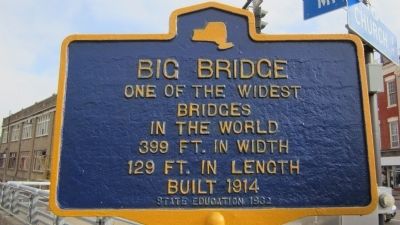
Big Bridge
Erected 1932 by NY State Education Department.
Topics and series. This historical marker is listed in this topic list: Bridges & Viaducts. In addition, it is included in the Erie Canal series list. A significant historical year for this entry is 1914.
Location. 43° 10.183′ N, 78° 41.64′ W. Marker is in Lockport, New York, in Niagara County. Marker is at the intersection of Main Street and Church Street, on the left when traveling east on Main Street. From NY 78 north, pass the NY 31 junction and cross a bridge to the next traffic light and turn right. The marker is NOT on NY 31. Touch for map. Marker is at or near this postal address: 1 Main Street, Lockport NY 14094, United States of America. Touch for directions.
Other nearby markers. At least 8 other markers are within walking distance of this marker. Canal Comparisons (within shouting distance of this marker); “Lockport Flight of Five” (within shouting distance of this marker); Upson Park (within shouting distance of this marker); a different marker also named The “Big Bridge” (within shouting distance of this marker); Tour Boat Then & Now (within shouting distance of this marker); Lower Lock Construction (within shouting distance of this marker); Hydraulic Race Control Gates (about 300 feet away, measured in a direct line); Lockport Municipal Building (about 300 feet away). Touch for a list and map of all markers in Lockport.
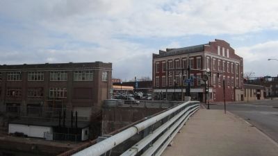
Regarding Big Bridge. The Big Bridge carries traffic from Main Street to West Avenue in a straight line over the Erie Canal at a very sharp angle, with parking lots actually on the bridge on both sides, making it difficult to perceive as a bridge when driving across. This generally east-west crossing of the bridge is Locks Plaza; the address for City Hall is 1 Locks Plaza (see picture at left). Church Street and Saxton Street also cross the Big Bridge. The portion of the local Erie Canal tour boat ride under the Big Bridge is like traveling in a long industrial water tunnel.
Also see . . .
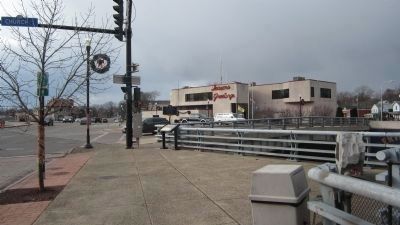
1. Historic Bridges.org - Big Bridge. Unfortunately, the Friendly's Restaurant seen in a picture of the Big Bridge here has been shuttered. (Submitted on December 7, 2013, by Anton Schwarzmueller of Wilson, New York.)
2. Lockport Union Sun and Journal - Big Bridge article, June 2013. (Submitted on December 7, 2013, by Anton Schwarzmueller of Wilson, New York.)
Photographed By Anton Schwarzmueller, December 7, 2013
2. Westward Crossing
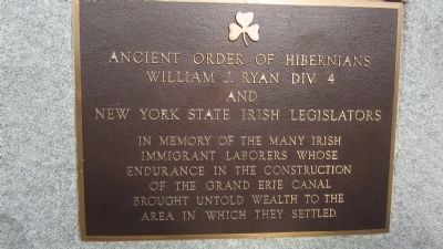
The Marker is at center. City Hall is behind the marker. Church Street crosses the bridge from the marker to the right of City Hall. The stone building with the red roof in the distance is where Saxton Street crosses the bridge from the south. Information pertaining to canal locks is posted in front of the marker. A memorial plaque for workers that built the Erie Canal is on the stone at the right.
Photographed By Anton Schwarzmueller, December 7, 2013
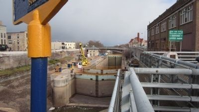
4. East View off Bridge at Marker
View of Locks 34 & 35 on the Erie Canal with part of the marker in the foreground. This is where canal traffic climbs the Niagara Escarpment. The Canal has been drained for the winter. The Pine Street Bridge is in the distance. The stone building with a red roof in the distance was originally a mill that was converted to City Hall before the current City Hall was built.
Credits. This page was last revised on June 16, 2016. It was originally submitted on December 7, 2013, by Anton Schwarzmueller of Wilson, New York. This page has been viewed 769 times since then and 48 times this year. Photos: 1, 2, 3, 4, 5. submitted on December 7, 2013, by Anton Schwarzmueller of Wilson, New York. • Bill Pfingsten was the editor who published this page.
