McLean in Fairfax County, Virginia — The American South (Mid-Atlantic)
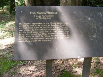
Fort Marcy, Virginia
A Civil War Defense of Washington
Erected by National Park Service.
Topics and series. This historical marker is listed in these topic lists: Forts and Castles • War, US Civil. In addition, it is included in the Defenses of Washington series list. A significant historical month for this entry is September 1771.
Location. 38° 56.044′ N, 77° 7.527′ W. Marker is in McLean, Virginia, in Fairfax County. Marker can be reached from George Washington Memorial Parkway, 3.9 miles west of U.S. 29, on the right when traveling west. Touch for map. Marker is in this post office area: Mc Lean VA 22101, United States of America. Touch for directions.
Other nearby markers. At least 8 other markers are within walking distance of this marker. A different marker also named Fort Marcy (a few steps from this marker); Auxiliary Battery (about 300 feet away, measured in a direct line); Inlet Locks (approx. 0.4 miles away in Maryland); Pimmit Run and Chain Bridge (approx. half a mile away); The Mouth of Pimmit Run (approx. half a mile away); Chain Bridge (approx. 0.6 miles away); Original Federal Boundary Stone, District of Columbia, Northwest 4 (approx. 0.6 miles away in Maryland); Clay and Randolph Duel (approx. 0.6 miles away). Touch for a list and map of all markers in McLean.
Also see . . . Fort Marcy Park. National Park Service (Submitted on December 10, 2013.)
Credits. This page was last revised on September 30, 2022. It was originally submitted on December 10, 2013, by Don Morfe of Baltimore, Maryland. This page has been viewed 914 times since then and 23 times this year. Photos: 1, 2, 3, 4. submitted on December 10, 2013, by Don Morfe of Baltimore, Maryland. • Bernard Fisher was the editor who published this page.


