Derry-Londonderry in Derry And Strabane, Northern Ireland, United Kingdom — Northwestern Europe (the British Isles)
Battle of the Bogside
The Guide to Free Derry
[Side A]
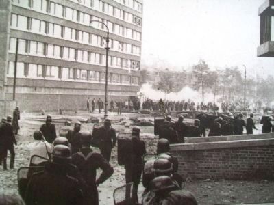
On 12 August 1969, as the Apprentice Boys Parade passed the edge of the Bogside, nationalists clashed with parade followers and police. The police and loyalists followed the nationalists back into the Bogside, where defences had been prepared. For the next three days this community held off a sustained attack from the police, who couldn’t pass the defenders on the roof of Rossville Flats. On 14 August the British army was brought in to replace the defeated and exhausted police.
Cath Thaobh An Bhogaigh
Ar an 12 Lúnasa 1969, mar a chuaigh Paráid na bPrintíseach thar imeall Thaobh an Bhogaigh, chuaigh náisiúnaithe i ngleic le leantóirí na Paráide agus le péas. Lean na peas agus na dílseoirí na náisiúnaithe ar ais isteach i dTaobh an Bhogaigh, mar ar ullmhaíodh cosaintí. Le linn na chéad frí lá eile choinnigh an pobal seo ionsaí marthanach ós na peas nach bhféadfadh dul thar na cosantóiri ar dhíon Árasáin Rossville. Ar an 14 Lúnasa tugadh Arm na Breataine isteach chun na peas cloíte agus traochta a ionadú.
[Front side photo captions read from top to bottom]
RUC office in full riot gear.
Bogside youths on the roof of Rossville Street high flats.
RUC officers use their shields for protection from a hail of missiles.
Hundreds of CS Gas cannisters were fired into the Bogside over the three days. (All photos courtesy of Barney McMonagle.)
[Side B]
Aggro Corner
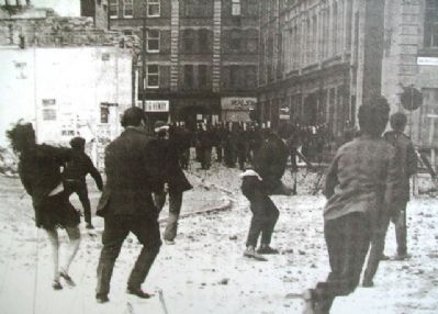
Aggro Corner was the area between the British army and RUC in Williams Street and the no-go area of the Bogside. It was a regular battle ground between soldiers and youths from Free Derry where clouds of CS gas and a hail of rubber bullets met stones and petrol bombs.
Topics. This historical marker is listed in these topic lists: Civil Rights • Disasters • Patriots & Patriotism. A significant historical year for this entry is 1969.
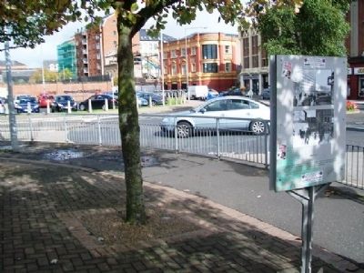
Location. 54° 59.891′ N, 7° 19.444′ W. Marker is in Derry-Londonderry, Northern Ireland, in Derry And Strabane. Marker is at the intersection of Rossville Street (B527) and William Street (B527), on the left when traveling north on Rossville Street (B527). Marker is southwest adjacent to the roundabout. Touch for map. Marker is in this post office area: Derry-Londonderry, Northern Ireland BT48 6ET, United Kingdom. Touch for directions.
Other nearby markers. At least 8 other markers are within walking distance of this marker. Mc Nutt, Phelan, and Mc Shane Memorial (a few steps from this marker); The Peace Mural (within shouting distance of this marker); Hunger Strike (about 90 meters away, measured in a direct line); Bloody Sunday (about 150 meters away); Civil Rights (about 150 meters away); a different marker also named Bloody Sunday (about 180 meters away); Hangman's Bastion (about 180 meters away); Castle Gate (about 210 meters away). Touch for a list and map of all markers in Derry-Londonderry.
Also see . . . The Northern Ireland Archives: Battle of the Bogside. (Submitted on January 22, 2014, by William Fischer, Jr. of Scranton, Pennsylvania.)
Credits. This page was last revised on August 27, 2020. It was originally submitted on January 22, 2014, by William Fischer, Jr. of Scranton, Pennsylvania. This page has been viewed 789 times since then and 24 times this year. Photos: 1, 2, 3, 4, 5. submitted on January 22, 2014, by William Fischer, Jr. of Scranton, Pennsylvania.
![Battle of the Bogside Marker [Side A]. Click for full size. Battle of the Bogside Marker [Side A] image. Click for full size.](Photos2/265/Photo265182.jpg?1222014113500PM)
![Battle of the Bogside Marker [Side B]. Click for full size. Battle of the Bogside Marker [Side B] image. Click for full size.](Photos2/265/Photo265183.jpg?1222014113600PM)


