Fritch in Hutchinson County, Texas — The American South (West South Central)
Antelope Creek Ruins
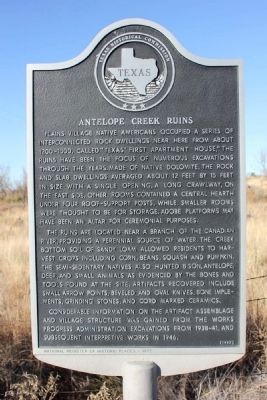
The ruins are located near a branch of the Canadian River, providing a perennial source of water. The creek bottom soil of sandy loam allowed residents to harvest crops including corn, beans, squash and pumpkin. The semi-sedentary natives also hunted bison, antelope, deer, and small animals as evidenced by the bones and tools found at the site. Artifacts recovered include small arrow points, beveled and oval knives, bone implements, grinding stones, and cord marked ceramics.
Considerable information on the artifact assemblage and village structure was gained from the Works Progress Administration excavations from 1938-41, and subsequent interpretive works in 1946.
Inscription
National Register of Historic Places - 1972
Erected 1997 by Texas Historical Commission. (Marker Number 12095.)
Topics. This historical marker is listed in these topic lists: Anthropology & Archaeology • Native Americans. A significant historical year for this entry is 1946.
Location. 35° 37.481′ N, 101° 32.114′ W. Marker is in Fritch, Texas, in Hutchinson County. Marker is at the intersection of State Highway 136 and Antelope Creek Road (County Route 136), on the right when traveling west on State Highway 136. Touch for map. Marker is in this post office area: Fritch TX 79036, United States of America. Touch for directions.
Other nearby markers. At least 8 other markers are within 9 miles of this marker, measured as the crow flies. First Rotary Drilling Rig Used in Texas Panhandle (approx. 7.4 miles away); Gulf Burnett No. 2 (approx. 7.4 miles away); Site of John and Maggie Weatherly Half-Dugout Site (approx. 7˝ miles away); Fort Smith-Santa Fe Trail (approx. 7.6 miles away); Beale Road (approx. 7.6 miles away); Girl Scout Little House (approx. 8.4 miles away); First Methodist Church of Borger (approx. 8˝ miles away); Ace Borger Home (approx. 8.8 miles away).
Also see . . . Antelope Creek Culture (1150 AD to 1450 AD). National Park Service (Submitted on February 18, 2014.)
Credits. This page was last revised on August 3, 2023. It was originally submitted on February 17, 2014, by Marvin Seibert of Ketchikan, Alaska. This page has been viewed 1,088 times since then and 48 times this year. Photos: 1, 2. submitted on February 17, 2014, by Marvin Seibert of Ketchikan, Alaska. 3. submitted on August 1, 2023, by Jeff Leichsenring of Garland, Texas. • Bernard Fisher was the editor who published this page.


