Near Boise in Ada County, Idaho — The American West (Mountains)
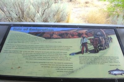
The Fur Trade and the Tide of Emigration
When American fur trappers appeared on the scene, it became Hudsonís Bay Company policy to deplete the beaver supply in southern Idaho. The trappers dramatically reduced beaver populations, putting the fur trade in decline by the 1830s. Yet, by then, the trappers had blazed the future Oregon Trail across southern Idaho for the tide of emigration to follow.
Settlers began emigrating in large numbers after 1843. During the next 25 years more than a half million people journeyed West, seeking free land, new opportunities, and helping to claim the area for the United States. Wagon trains left the Missouri River in early spring and reached southern Idaho in late summer. Fear of Indian hostilities, blazing heat, choking dust, relentless thirst, and sheer tedium made crossing Idahoís Snake River Plain dreaded and difficult.
When the emigrants reached Bonneville Point, they viewed the wooded banks of the Boise River below and knew they had survived the hardships. Upon arrival here, they had traveled 1,450 miles and completed two-thirds of their journey.
“proceeded down Reedís (Boise) River. At the end of three daysí toil we got clear of the mountains and into a highly picturesque and open country well furnished with animals of the chace. Our first lift of beaver was 64-. Added to this charming prospect six elks and seventeen small deer coming into camp at once filled a starving and dissatisfied people with abundance - and for a moment my people were cheerful, industrious, and obedient.”
--Alexander Ross, 1824
Topics. This historical marker is listed in these topic lists: Exploration • Industry & Commerce • Settlements & Settlers. A significant historical year for this entry is 1821.
Location. 43° 29.516′ N, 116° 2.438′ W. Marker is near Boise, Idaho, in Ada County. Marker can be reached from S. Upper Blacks Creek Road, 1.3 miles north of E. Blacks Creek Road. Marker is located at the Bonneville Point interpretive site along the route of the Oregon Trail at the end of S. Upper Blacks Creek Road. Touch for map. Marker is in this post office area: Boise ID 83716, United States of America. Touch for directions.
Other nearby markers. At least 8 other markers are within 4 miles of this marker, measured as the crow flies. The Hunt Expedition (here, next to this marker); The Shoshone and Northern Paiute (here, next to this marker); Captain Bonneville (here, next to this marker); Bonneville Point (a few steps from this marker); Site 10 ★ Blacks Creek Road Crossing (approx. 1.1 miles away); The Foote Legacy in Idaho (approx. 2.6 miles away); Basque Country (approx. 3.4 miles away); Oregon Trail (approx. 3Ĺ miles away). Touch for a list and map of all markers in Boise.
Credits. This page was last revised on November 2, 2018. It was originally submitted on February 17, 2014, by Duane Hall of Abilene, Texas. This page has been viewed 660 times since then and 21 times this year. Photos: 1. submitted on February 17, 2014, by Duane Hall of Abilene, Texas. 2. submitted on November 2, 2018, by Barry Swackhamer of Brentwood, California. 3. submitted on February 17, 2014, by Duane Hall of Abilene, Texas.
Editor’s want-list for this marker. Photo of wide-view of marker and surroundings. • Can you help?


