Port Tobacco in Charles County, Maryland — The American Northeast (Mid-Atlantic)
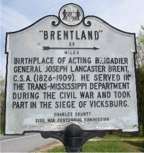
"Brentland"
2.6 miles →
Erected by Charles County Civil War Centennial Commission.
Topics. This historical marker is listed in this topic list: War, US Civil.
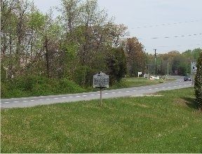
Location. 38° 29.424′ N, 77° 4.072′ W. Marker is in Port Tobacco, Maryland, in Charles County. Marker is at the intersection of Blossom Point Road and Port Tobacco Road (Maryland Route 6), on the right when traveling east on Blossom Point Road. Touch for map. Marker is at or near this postal address: 8100 Blossom Point Road, Port Tobacco MD 20677, United States of America. Touch for directions.
Other nearby markers. At least 8 other markers are within 3 miles of this marker, measured as the crow flies. The Retreat (approx. 1.7 miles away); Daniel of St. Thomas Jenifer (approx. 2.2 miles away); Chapel Point Park (approx. 2.8 miles away); Port Tobacco (approx. 2.8 miles away); Mulberry Grove (approx. 2.8 miles away); John Hanson (approx. 2.9 miles away); The Port Tobacco Jail (approx. 2.9 miles away); Ways to Explore Southern Maryland’s Scenic and Historic Routes (approx. 2.9 miles away). Touch for a list and map of all markers in Port Tobacco.
Also see . . . Brentland, Maryland Inventory of Historic Properties. (Submitted on January 17, 2019.)
Credits. This page was last revised on December 15, 2019. It was originally submitted on April 20, 2008, by M. A. Pimentel of Waldorf, Maryland. This page has been viewed 1,804 times since then and 26 times this year. Photos: 1, 2. submitted on April 20, 2008, by M. A. Pimentel of Waldorf, Maryland. • Craig Swain was the editor who published this page.

