Near Winterset in Madison County, Iowa — The American Midwest (Upper Plains)
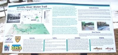
Middle River Water Trail
Roseman Covered Bridge to Pammel Park
[Historical excerpts from marker]
The Middle River has its origin in south-central Guthrie County. However, the navigable section of Middle River begins in east-central Adair County near Middle River Forest County Park. Middle River is a scenic stream that flows easterly through a mixture of lazy country side of croplands and pasture, rolling forested hills and limestone bluffs. It twists and turns through these landforms creating a moderately challenging paddle, especially at high or low water levels. This stream provides an exciting paddle with occasional chutes and ledges that can be navigated with moderate effort. Water levels are most enjoyable for paddling in spring, early summer and fall.
Along with the natural beauty found along Middle River, there are also a few man-made attractions that add to the scenery and water-trail experience. Spanning the river is two of Madison County's famous "Bridges of Madison County", Roseman Covered Bridge and Holliwell Covered Bridge. Paddlers must also portage around the historic "ford" at Pammel Park that was built in the early 1900's, and while making portage one can also catch a glimpse of the "Harmon Tunnel" originally constructed in 1858.
Middle River eventually empties into the Des Moines River near Carlisle in northern Warren County - with this navigable section of river being approximately 100 miles in length. The designated Middle River Water Trail begins at Middle River Forest County Park in Adair County and currently ends at the historic Holliwell Covered Bridge approximately 3½ miles SE of Winterset, covering a distance of just over 45 miles. Enjoy your exploration of Middle River!
Cultural Resources
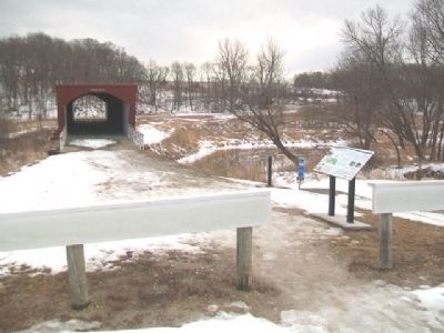
The most interesting cultural aspects along this stretch of Middle River is obviously Roseman Covered Bridge. Roseman Bridge was completed in 1883 and was built by a local bridge builder by the name of Benton Jones. Although only six covered bridges remain, there were many covered bridges that once dotted Madison County in the early 19th century - all built by local bridge builders, with each builder utilizing his own engineering design that uniquely separated the various construction styles of Madison County's six covered bridges still standing today.
Many still ask the question, "Why did they cover the bridges"? They were covered to protect them from the weather and extend their longevity. In 1870 the Board of Supervisors adopted new rules for bridge construction that included the requirement that they be "covered" sighting that "the expense of the roof is more than made up by the permanency of the bridge." The bridges ranged in cost from $900 to $1,900. One historian quipped, "Bridges
were covered for the same reasons women wore hoop skirts and crinolines - to protect the beauty seldom seen, but nonetheless appreciated."
Roseman Bridge is called the haunted bridges which is related to a story of a split posse that surrounded the bridge trying to capture an escapee from the local jail who was hiding inside the bridge. In gathering darkness the posse entered from both ends of the bridge and a scuffle provided the escapee a chance to 'disappear' -- not be found inside the bridge. Locals often hear wild laughter coming from the bridge and it is assumed it is the ghost of the man who had avoided capture.
These remaining covered bridges paint a story of pioneer people who took what they had and did the most with it. These structures which are attractive, durable and useful, are a tribute to a generation of pioneers who left a land better than they found it and leaves to use a link with a romantic past.
River Touring
Beginning at one of the celebrated "Bridges of Madison County" and ending at one of central Iowa's oldest and scenic parks, this section twists and turns through a myriad of natural attractions, from scenic limestone bluffs and woodlands to brief sections of cropland and pastures. As the gradient suggests, you should expect moderately challenging paddling as you drop down through numerous chutes and ledges.
Geology
Madison County escaped the most recent glaciations of approximately 12,000 to 15,000 years ago and is thus part of the Southern Iowa Drift Plain. The exterior appearance of Madison County is prominently dominated by the rolling hills which are shaped and supported by thick layers of limestone and shale formed millions of years ago during the era when a vast area of the Midwest was part of the Carboniferous Sea. The geology of Madison County becomes most striking when canoeing our rivers. Dispersed primarily through the central region of Madison County, majestic limestone walls and cliffs, with layers of shale intermixed, greet river users, with the most prominent high cliffs over 140' in height, found along Middle River about 1 mile above Pammel Park.
Erected by Iowa Dept of Natural Resources, Iowa Water Trails, and Madison County and Adair County Conservation Boards.
Topics and series. This historical marker is listed in these topic lists: Bridges & Viaducts • Environment • Waterways & Vessels. In addition, it is included in the Covered Bridges series list. A significant historical year for this entry is 1858.
Location. 41° 17.588′ N, 94° 9.001′ W. Marker is near Winterset, Iowa, in Madison County. Marker is on Elderberry Avenue south of Roseman Bridge Road, on the right when traveling south. Marker is at the end of the road, at the northwest approach to the Roseman Covered Bridge, and about six miles WSW of Winterset. Touch for map. Marker is at or near this postal address: 2451 Elderberry Avenue, Winterset IA 50273, United States of America. Touch for directions.
Other nearby markers. At least 8 other markers are within 8 miles of this marker, measured as the crow flies. Roseman Covered Bridge (here, next to this marker); Carnegie Building (approx. 7˝ miles away); George Leslie Stout (approx. 7.6 miles away); 102 West Court Avenue (approx. 7.6 miles away); 102 North 1st Avenue (approx. 7.6 miles away); 106 North 1st Avenue (approx. 7.6 miles away); 108 North 1st Avenue (approx. 7.6 miles away); 52 Court Avenue (approx. 7.6 miles away). Touch for a list and map of all markers in Winterset.
Also see . . .
1. Madison County Parks Water Trail. (Submitted on March 19, 2014, by William Fischer, Jr. of Scranton, Pennsylvania.)
2. At Play: River Relationships (The Iowan). (Submitted on March 19, 2014, by William Fischer, Jr. of Scranton, Pennsylvania.)
Credits. This page was last revised on August 31, 2020. It was originally submitted on March 19, 2014, by William Fischer, Jr. of Scranton, Pennsylvania. This page has been viewed 448 times since then and 16 times this year. Photos: 1, 2. submitted on March 19, 2014, by William Fischer, Jr. of Scranton, Pennsylvania.

