Irvinestown in Fermanagh And Omagh, Northern Ireland, United Kingdom — Northwestern Europe (the British Isles)
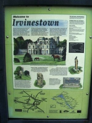
Welcome to Irvinestown
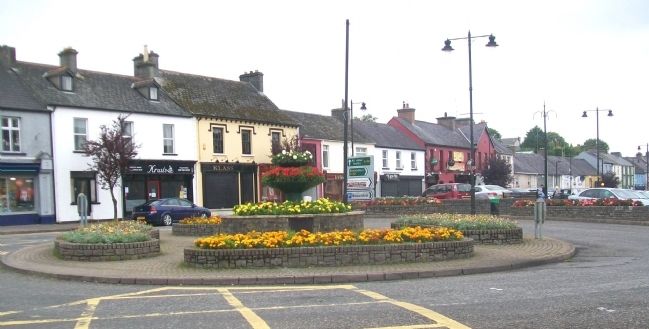
The town takes its name from the Irvine family who were the landlords of the district and came from Bonshaw in Scotland in the 17th century. They lived at Castle Irvine which today is known as Necarne Castle. The town was first known as Lowtherstown but in the 1860's its name was changed to Irvinestown. It is the third largest town in Fermanagh with a population of 2,244. It is famous for its wide Main Street and ample parking facilities. The town is proud of its vision, innovation and commitment to community life which has been inspired by a group of townsfolk, 7 Protestants and 7 Roman Catholics who came together in 1908 to form the Fairs & Market Trustees. During the Second World War the town was host to hundreds of Allied airforce men and women who were stationed at Castle Archdale and Killadeas.
Necarne Castle & the Ulster Lakeland Equestrian Park
Necarne Castle, once known as Castle Irvine, is within walking distance of the town. Today it is only a shell of its former self and it is hard to believe it was once the centre of social activity for the area. During the Second World War the Americans and RAF used it as a military hospital. It is home to the Ulster Lakeland Equestrian Park with its state of the art indoor arena and walled garden where dressage events take place. Equestrian competitions are held throughout the year. Those who love quiet uninterrupted walks will be spoiled for choice in the 200 acres of rolling pastureland and wooded glades.
Town Clock & Graveyard
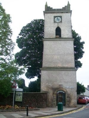
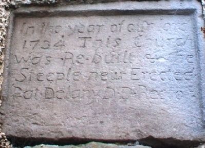
The town clock at the southern end of the Main Street stands over the town. It is the only remnant from an earlier 17th century church and the inscription stone over the doorway records: "In the year of our Lord 1734, this church was rebuilt and the steeple erected. Pat Delany, DD Rector". The Millennium light shining through the four louvered windows is a reminder of the role young people play in the life of the town. The adjoining graveyard has been tastefully refurbished with wheelchair access being added. This is a community graveyard and headstones showing the skill of earlier stonemasons date back to the end of the 17th century. Wrought iron gates at the entrance reflect the workings of the clock. Further information available at the local library.
Bishop's Stone - Killadeas Graveyard
In this Church of Ireland graveyard there is an interesting sculptured stone which probably dates back to either the ninth, tenth, or possibly eleventh century. It is known as the Bishop's Stone and is carved on its west side with a face and on its south side with an abbot or bishop carrying a crozier and bell. A stone nearby shows a carving of a small Greek cross.
Lady
of the Lake Statue
Each year in the month of July, the Lady of the Lake Festival commemorates a local legend of a beautiful mysterious woman surrounded by a light and gliding over the islands of Lough Erne and on her way passing Inishmacsaint, Inisgarve, Inisdoney, Inisclare and Inisglorraigh. Folklore said she was a sign of good times ahead and she carried in her hand a bunch of wild flowers. Locals and visitors alike are welcomed for this highlight of the town's festive calendar and all are assured of a time they will not forget. The statue at the junction of Pound and Bridge Street was designed by sculptor Philip Flanagan and was unveiled on the 18th December 1999 by Dr Aideen McGinley (Chief Executive of Fermanagh District Council).
Famine Graveyard
The Famine Graveyard situated in Reihill Park bears testimony to a time when hunger and famine stalked the land between 1845-1850. The solitary memorial stone reminds use [sic] of the many nameless paupers buried in this graveyard. The inscription stone 1841 was once over the doorway of Irvinestown Workhouse and now can be seen at the entrance to Reihill Park.
The Natural Environment
Lower Lough Erne and its islands contain a variety of woodland and shoreline habitats and are home to four protected species notably the lapwing, curlaw, red shank and snipe.
Other Sites of Interest [partial list]
Castle Archdale Country Park and World War II Flying Boat Base White Island, Devenish Island, Sheemuldoon Chambered Grave, Caldragh Janus Stone, Drumskinny Stone Circle, Ardess Famine Grave, Ardess Craft Centre, [?] Iron Age Graveyard
Church of Ireland & Roman Catholic Graveyards
War graves of Allied Airforce men are located in these cemeteries. These were men who were based at Castle Archdale or Killadean during the Second World War (1939-1945) and they lost their lives whilst on operational duty flying Catalina and Sunderland flying boats.
Other attractions for visitor:
Belleek Pottery, Castle Coole, Marble Arch Caves, Florencecourt, Ulster American Folk Park, Enniskillen Castle Museum.
Thanks to the people of Irvinestown for their assistance in the production of this panel. (Illustrations by Dan Powell)
Erected by Irvinestown Fairs & Markets Trustees, Irvinestown Community Partnership, & Flag EU Leader II Programme.
Topics. This historical marker is listed in these topic lists: Cemeteries & Burial Sites • Man-Made Features • Settlements & Settlers • War, World II. A significant historical date for this entry is December 18, 1999.
Location. 54° 28.269′ N, 7° 38.015′ W. Marker is in Irvinestown, Northern
Ireland, in Fermanagh And Omagh. Marker is at the intersection of Castle Street and Mill Street (A32), on the left when traveling south on Castle Street. Touch for map. Marker is at or near this postal address: 2 Castle Street, Irvinestown, Northern Ireland BT94 1EH, United Kingdom. Touch for directions.
Other nearby markers. At least 8 other markers are within 14 kilometers of this marker, measured as the crow flies. Memorials to the Great Irish Famine in County Fermanagh (approx. 0.4 kilometers away); Centenary Gardens House 2 (approx. 0.4 kilometers away); Centenary Gardens House 1 (approx. 0.4 kilometers away); South Africa War Memorial (approx. 13.9 kilometers away); German 77mm Light Artillery Gun (approx. 13.9 kilometers away); The Watergate and Flag of St George (approx. 13.9 kilometers away); German 21cm Mortar, 1918 (approx. 13.9 kilometers away); Cole's Monument (approx. 14 kilometers away). Touch for a list and map of all markers in Irvinestown.
Credits. This page was last revised on July 24, 2018. It was originally submitted on March 26, 2014, by William Fischer, Jr. of Scranton, Pennsylvania. This page has been viewed 1,101 times since then and 111 times this year. Photos: 1, 2, 3, 4. submitted on March 26, 2014, by William Fischer, Jr. of Scranton, Pennsylvania.


