Venice in Sarasota County, Florida — The American South (South Atlantic)
Fred Albee Municipal Airport
Inscription.
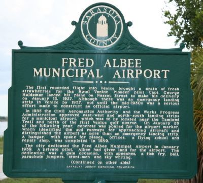
The first recorded flight into Venice brought a crate of fresh strawberries for the Hotel Venice. Pioneer pilot Capt. George Haldeman landed his plane on Nassau Street to make his delivery on January 13, 1927, not until the mid-1930s was a serious effort made to construct an official airport.
In 1935 the Civil Aeronautics Authority and the Works Progress Administration approved east-west and north-south landing strips for a municipal airport, which was to be located near the Tamiami Trail and north of the first Venice golf course. On January 26 of the following year, concrete was poured for the airport marker, which identified the sod runways for approaching aircraft and distinguished the airport as more than an emergency landing strip. A hanger, with space for planes, offices, a flying school and repair shop, was completed in 1939.
The city dedicated the Fred Albee Municipal Airport in January 1939. A private pilot, Albee had given land for the airport. The dedication was a gala occasion, with speeches, a fish fry, ball, parachute jumpers, stunt-men and sky writing.
Reverse:
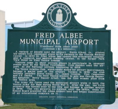
A variety of people used the airport. Steve Albee, Jr., piloted his uncle's five-passenger plane to fly patients to the Florida Medical Center. In 1933 Dr. Fred Albee had opened this orthopedic hospital, also a research and medical training center, in the former Park View Hotel on West Venice Avenue.
Visitors came in their private planes to participate in seasonal events such as the Tarpon Tournament. Crop dusters used the airport, as did National Airlines beginning in 1939.
The Venice Aviation Club, which raised money for airport improvements, became a major user of the airport. Formed in 1938, the club initially included Steve Albee, Jr., James Cousins, Finn Caspersen and J.E. Darby. The first Venice student to solo was George Hauser. His daughter, Betty Hauser Arnall, was the first woman pilot from the Venice area.
The Army Air Corps used the municipal airport while it built the Venice Army Air Base during World War II. After the war, the VAAB property was turned over to the city and became a civilian airport in 1946. The two airports co-existed until the 1950s, when the School Board acquired the Albee Airport land and began construction of an educational complex on it.
Erected by Sarasota County Historical Commission.
Topics and series. This historical marker is listed in these topic lists: Air & Space • Industry & Commerce • War, World II. In addition, it is included in the Works Progress Administration (WPA) projects series list. A significant historical month for this entry is January 1843.
Location.
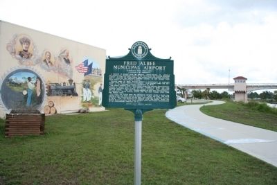
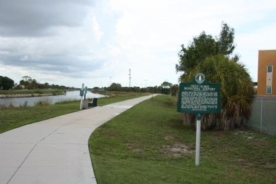
27° 5.926′ N, 82° 26.456′ W. Marker is in Venice, Florida, in Sarasota County. Marker can be reached from Venice Avenue south of American Legion Way. This historical marker is located along a community walking path that runs along the west side of the intracoastal waterway, and under the Venice Avenue Bridge that spans the intracoastal waterway. It is situated along a portion of the walking path that is entitled "Venice Remembrances" and is overlooked by a mural on the side of a building that features events in the history of the City of Venice. Touch for map. Marker is in this post office area: Venice FL 34285, United States of America. Touch for directions.
Other nearby markers. At least 8 other markers are within walking distance of this marker. Gunther Gebel-Williams (approx. 0.2 miles away); Colonel George Kumpe Bridge (approx. ¼ mile away); Johnson-Schoolcraft Building 1926 (approx. 0.3 miles away); Ennes Arcade and Hotel Valencia 1926 (approx. 0.4 miles away); Kentucky Military Institute (approx. 0.4 miles away); The Supreme Sacrifice (approx. 0.4 miles away); San Marco Hotel (approx. 0.4 miles away); a different marker also named Kentucky Military Institute (approx. 0.4 miles away). Touch for a list and map of all markers in Venice.

Photographed By Dale K. Benington, July 1, 2010
4. Fred Albee Municipal Airport Marker
View looking north of the historical marker with a mural featuring the history of the City of Venice in the left background and in the right background is a view of the walking path and the Venice Avenue Bridge (aka Colonel George Kumpe Bridge) crossing the intracoastal waterway.
Credits. This page was last revised on January 3, 2020. It was originally submitted on July 3, 2010, by Dale K. Benington of Toledo, Ohio. This page has been viewed 1,003 times since then and 25 times this year. Last updated on May 13, 2014. Photos: 1, 2, 3, 4. submitted on July 3, 2010, by Dale K. Benington of Toledo, Ohio. • Bernard Fisher was the editor who published this page.


