Chester in Chesterfield County, Virginia — The American South (Mid-Atlantic)
The Battle of Ware Bottom Church
The Bermuda Hundred Campaign
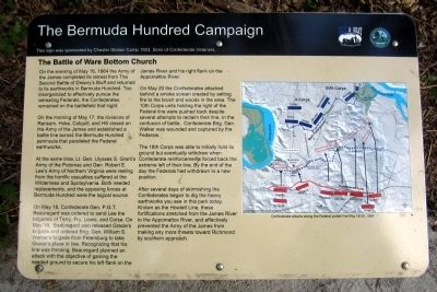
On the morning of May 17, the divisions of Ransom, Hoke, Colquitt, and Hill closed on the Army of the James and established a battle line across the Bermuda Hundred peninsula that paralleled the Federal earthworks.
At the same time, Lt. Gen. Ulysses S. Grant's Army of the Potomac and Gen. Robert E. Lee's Army of Northern Virginia were reeling from the horrific casualties suffered at the Wilderness and Spotsylvania. Both needed replacements, and the opposing forces at Bermuda Hundred were the logical source.
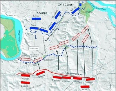
On May 18, Confederate Gen. P.G.T. Beauregard was ordered to send Lee the brigades of Terry, Fry, Lewis, and Corse. On May 19, Beauregard also released Gracie's brigade and ordered Brig. Gen. William S. Walker's brigade from Petersburg to take Gracie's place in line. Recognizing that his line was thinning, Beauregard planned an attack with the objective of gaining the needed ground to secure his left flank on the James River and his right flank on the Appomattox River.
On May 20 the Confederates attacked behind a smoke screen created by setting fire to the brush and woods in the area. The 10th Corps units holding the right of the Federal line were pushed back despite several attempts to reclaim their line. In the confusion of battle, Confederate Brig. Gen. Walker was wounded and captured by the Federals.
The 18th Corps was able to initially hold its ground but eventually withdrew when Confederate reinforcements forced back the extreme left of their line. By the end of the day the Federals had withdrawn to a new position.
After several days of skirmishing the Confederates began to dig the heavy earthworks you see in this park today. Known as the Howlett Line, these fortifications stretched from the James River to the Appomattox River, and effectively prevented the Army of the James from making any more threats toward Richmond by southern approach.
(caption)
Confederate attacks along the Federal picket line May 18-20, 1864
This sign was sponsored by Chester Station Camp 1503. Sons of Confederate Veterans
Erected 2014 by Chesterfield County and the Blue & Gray Education Society.
Topics and series. This historical marker is listed in this topic list: War, US Civil. In addition, it is included in the Sons of Confederate Veterans/United Confederate Veterans series list. A significant historical date for this entry is May 16, 1863.
Location. 37° 20.569′ N, 77° 23.347′ W. Marker is in Chester, Virginia, in Chesterfield County. Marker can be reached from Old Bermuda Hundred Road east of Ramblewood Drive, on the right when traveling east. Located in Ware Bottom Church Battlefield Park. Touch for map. Marker is at or near this postal address: 1600 Old Bermuda Hundred Rd, Chester VA 23831, United States of America. Touch for directions.
Other nearby markers. At least 8 other markers are within walking distance of this marker. A Bomb Proof Church ? (within shouting distance of this marker); Construction of the Howlett Line (about 700 feet away, measured in a direct line); Howlett Line Gun Position (approx. 0.2 miles away); Parker's Battery (approx. half a mile away); Remembrance (approx. half a mile away); a different marker also named Parker’s Battery (approx. half a mile away); Howlett Line (approx. half a mile away); a different marker also named Howlett Line (approx. half a mile away). Touch for a list and map of all markers in Chester.
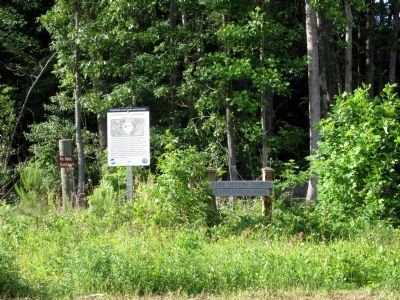
Photographed By Bernard Fisher, May 24, 2014
4. Ware-Bottom Church Battlefield Park
The land has been preserved by the Chesterfield Historical Society, Civil War Sites Committee, in partnership with the Chesterfield County Department of Parks and Recreation. The preservation was made possible by a federal grant from the Land and Water Conservation Fund. Matching funds for the grant were donated by G.E. Miles and Courtney Wells. The grant was administered by the American Battlefield Protection Program of the National Park Service. The survey for this property was donated by Harvey L. Parks, Inc.
Credits. This page was last revised on October 21, 2021. It was originally submitted on May 25, 2014, by Bernard Fisher of Richmond, Virginia. This page has been viewed 1,727 times since then and 112 times this year. Last updated on January 10, 2021, by Bradley Owen of Morgantown, West Virginia. Photos: 1. submitted on May 25, 2014, by Bernard Fisher of Richmond, Virginia. 2. submitted on August 26, 2015, by Bernard Fisher of Richmond, Virginia. 3, 4. submitted on May 25, 2014, by Bernard Fisher of Richmond, Virginia. 5. submitted on October 19, 2021, by Bradley Owen of Morgantown, West Virginia.
