Enon in Chesterfield County, Virginia — The American South (Mid-Atlantic)
Federal War Plans for 1864
The Bermuda Hundred Campaign
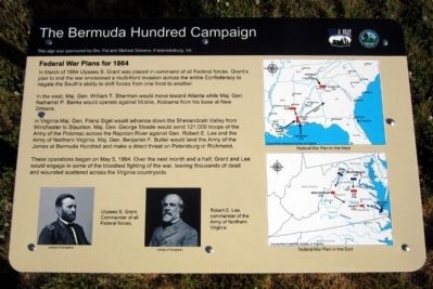
In the west, Maj. Gen. William T. Sherman would move toward Atlanta while Maj. Gen. Nathaniel P. Banks would operate against Mobile, Alabama from his base at New Orleans.
In Virginia Maj. Gen. Franz Sigel would advance up the Shenandoah Valley from Winchester to Staunton. Maj. Gen. George Meade would send 121,000 troops of the Army of the Potomac across the Rapidan River against Gen. Robert E. Lee and the Army of Northern Virginia. Maj. Gen. Benjamin F. Butler would land the Army of the James at Bermuda Hundred and make a direct threat on Petersburg or Richmond.
These operations began on May 5, 1864. Over the next month and a half, Grant and Lee would engage in some of the bloodiest fighting of the war, leaving thousands of dead and wounded scattered across the Virginia countryside.
(captions)
Ulysses S. Grant, Commander of all Federal forces. Library of Congress
Robert E. Lee, commander of the Amy of Northern Virginia Library of Congress
Federal War Plan in the West Chesterfield Historical Society of Virginia
Federal War Plan in the East Chesterfield Historical Society of Virginia
This sign was sponsored by Drs. Pat and Michael Stevens, Fredericksburg, VA
Erected 2014 by Chesterfield County and the Blue & Gray Education Society.
Topics. This historical marker is listed in this topic list: War, US Civil. A significant historical month for this entry is March 1864.
Location. 37° 19.444′ N, 77° 21.374′ W. Marker is in Enon, Virginia, in Chesterfield County. Marker can be reached from Enon Church Road (Virginia Route 746) west of Bermuda Orchard Lane, on the left when traveling west. Located in Point of Rocks Park. Touch for map. Marker is at or near this postal address: 201 Enon Church Road, Chester VA 23836, United States of America. Touch for directions.
Other nearby markers. At least 8 other markers are within walking distance of this marker. Actions in the East 1861-1863 (here, next to this marker); Confederate Leaders (approx. 0.2 miles away); The Bermuda Hundred Campaign-Federal Leaders (approx. 0.2 miles away); The Bermuda Hundred Campaign Begins (approx. 0.2 miles away); Welcome to R. Garland Dodd Park at Point of Rocks (approx. 0.2 miles away); Point of Rocks (approx. 0.2 miles away); Opening Actions of the Bermuda Hundred Campaign (approx. 0.3 miles away); Grant's Virginia Campaigns (approx. 0.3 miles away). Touch for a list and map of all markers in Enon.
Credits. This page was last revised on June 16, 2016. It was originally submitted on May 25, 2014, by Bernard Fisher of Richmond, Virginia. This page has been viewed 454 times since then and 21 times this year. Photos: 1, 2. submitted on May 25, 2014, by Bernard Fisher of Richmond, Virginia.

