Grafton in Taylor County, West Virginia — The American South (Appalachia)
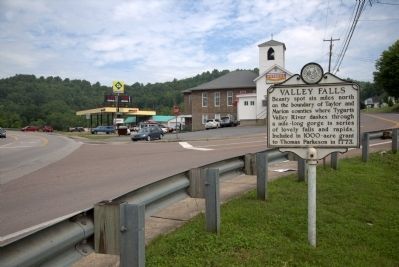
Valley Falls
Topics and series. This historical marker is listed in this topic list: Natural Features. In addition, it is included in the West Virginia Archives and History series list. A significant historical year for this entry is 1773.
Location. 39° 21.112′ N, 80° 2.27′ W. Marker is in Grafton, West Virginia, in Taylor County. Marker is at the intersection of U.S. 50 and West Virginia Route 310, on the right when traveling west on U.S. 50. Touch for map. Marker is in this post office area: Grafton WV 26354, United States of America. Touch for directions.
Other nearby markers. At least 8 other markers are within one mile of this marker, measured as the crow flies. Dedicated to the Memory of Thornsbury Bailey Brown (approx. 0.3 miles away); Old Catholic Cemetery (approx. 0.9 miles away); Veterans Memorial (approx. 0.9 miles away); Grafton Post Office (approx. one mile away); B&O Freight Station (approx. one mile away); Forcella Buildings (approx. one mile away); Latrobe Street (approx. one mile away); Bonafede Building (approx. one mile away). Touch for a list and map of all markers in Grafton.
Also see . . . Website for Valley Falls State Park . Excerpt: “Once the site of a lumber and grist mill community, the scenic treasure of Valley Falls State Park is located only a short drive from Fairmont and Grafton. This 1,145 acre day use park hosts a variety of outdoor recreation including fishing, picnicking, kayaking, and 18 miles of hiking and mountain biking trails.
“The beauty of the park is enhanced by the spectacular series of foaming falls which were created by the dark, rushing waters of the Tygart Valley River and provides a boundary between Marion and Taylor counties. The prevalent rock formation known as Connoquenessing Sandstone, forms the cap of the falls over which the river plunges and swirls and appears both as ledges and huge room size boulders for over a mile down the narrow canyon floor.
“Before Valley Falls became a state park, this section of the Tygart Valley River in the 1800s was a thriving railroad community and a popular recreation area. During this ‘boom’ period, Valley Falls had a B&O Railroad Depot Station, grist mill, post office, sawmills, shops and a ferry. Between 1886 and 1888, a fire and flood swept through the community. Some repairs were made but the town never fully recovered. In 1964, the state park system acquired the falls and the surrounding land. This picturesque river gorge became Valley Falls State Park.” (Submitted on July 3, 2014, by J. J. Prats of Powell, Ohio.)
Credits. This page was last revised on June 16, 2016. It was originally submitted on July 3, 2014, by J. J. Prats of Powell, Ohio. This page has been viewed 388 times since then and 11 times this year. Photos: 1, 2. submitted on July 3, 2014, by J. J. Prats of Powell, Ohio.
Editor’s want-list for this marker. Photos of the park • Can you help?

