Victoria in Victoria County, Texas — The American South (West South Central)
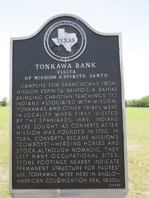
Tonkawa Bank
Visita of Mission Espiritu Santo
Erected 1970 by State Historical Survey Committee. (Marker Number 6572.)
Topics and series. This historical marker is listed in these topic lists: Churches & Religion • Hispanic Americans • Native Americans. In addition, it is included in the El Camino Real de los Tejas National Historic Trail series list. A significant historical year for this entry is 1689.
Location. This marker has been replaced by another marker nearby. 28° 49.446′ N, 97° 0.782′ W. Marker is in Victoria, Texas, in Victoria County. Marker is on McCright Drive, 0.2 miles west of North Vine Street, on the left when traveling west. Marker is in field near Victoria Parks and Recreation building. Touch for map. Marker is at or near this postal address: 476 McCright Drive, Victoria TX 77901, United States of America. Touch for directions.
Other nearby markers. At least 8 other markers are within walking distance of this location. A different marker also named Tonkawa Bank (here, next to this marker); Presidio La Bahia and Mission Espíritu Santo (a few steps from this marker); Old La Bahia Road (about 700 feet away, measured in a direct line); Victoria (about 700 feet away); Friedrich & Margaretha Hiller House (approx. 0.3 miles away); Steamboating and the Guadalupe River (approx. 0.3 miles away); William Robert Smith (approx. 0.8 miles away); Margaret Wright "The Mother of Texas" (approx. 0.9 miles away). Touch for a list and map of all markers in Victoria.
More about this marker. This marker was replaced by a new one named also named Tonkawa Bank (see nearby markers).
Also see . . . Tracing a Mission and Its People. Texas Beyond History web page that includes detail on the "Tonkawa Bank" site. (Submitted on July 5, 2014, by Richard Denney of Austin, Texas.)
Additional commentary.
1. Disposition of old marker.
Per e-mail from Gary Dunnam with Victoria County Historic Commission and Preservation Association,
the old marker has moved to the Victoria County Archives.
— Submitted September 9, 2019, by Richard Denney of Austin, Texas.

Photographed By Richard Denney
3. Tonkawa Bank Marker
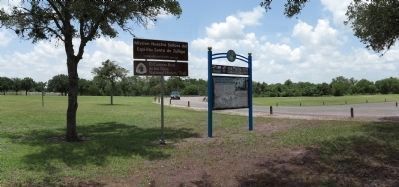
Site where marker is located is part of the El Camino Real de los Tejas National Historic Trail, Mission Nuestra Senora del Espiritu Santo de Zuniga
Tonkawa Bank Site, 1725-1726. Marker is visible in background behind and to left of signs erected by El Camino Real de los Tejas National Historic Trail Association
Credits. This page was last revised on September 13, 2019. It was originally submitted on July 5, 2014, by Richard Denney of Austin, Texas. This page has been viewed 729 times since then and 15 times this year. Photos: 1, 2, 3, 4. submitted on July 5, 2014, by Richard Denney of Austin, Texas. • Bernard Fisher was the editor who published this page.


