Near Fredericksburg in Spotsylvania County, Virginia — The American South (Mid-Atlantic)
First Day at Chancellorsville
The End of the First Day
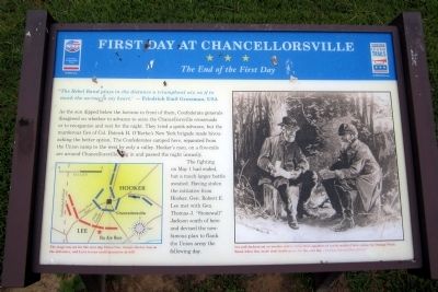
The Rebel Band plays in the distance a triumphant air, as if to mock the sorrow of my heart. — Friedrich Emil Grossman, USA
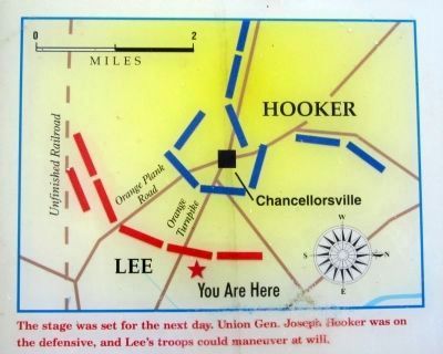
As the sun dipped below the horizon in front of them, Confederate generals disagreed on whether to advance to seize the Chancellorsville crossroads or to reorganize and rest for the night. They tried a quick advance, but the murderous fire of Col. Patrick H. O'Rorke's New York brigade made bivouacking the better option. The Confederates camped here, separated from the Union camp to the west by only a valley. Hooker's men, on a five-mile arc around Chancellorsville, dug in and passed the night uneasily.
The fighting on May 1 had ended, but a much larger battle awaited. Having stolen the initiative from Hooker, Gen. Robert E. Lee met with Gen. Thomas J. “Stonewall” Jackson south of here and devised the now-famous plan to flank the Union army the following day.
(captions)
(lower left) The stage was set for the next day. Union Gen. Joseph Hooker was on the defensive, and Lee's troops could maneuver at will. (right) Lee and Jackson sat on wooden crates about three-quarters of a mile south of here, along the Orange Plank Road, when they made their battle plans for the next day. — Courtesy National Park Service
Erected by Virginia Civil War Trails, Civil War Trust.
Topics and series. This historical marker is listed in this topic list: War, US Civil. In addition, it is included in the Virginia Civil War Trails series list. A significant day of the year for for this entry is May 1.
Location. 38° 18.083′ N, 77° 36.817′ W. Marker is near Fredericksburg, Virginia, in Spotsylvania County. Marker can be reached from Plank Road (Virginia Route 3) 0.8 miles west of Corter Avenue, on the right when traveling west. Located along the Lick Run Battlefield trail. Touch for map. Marker is at or near this postal address: 6161 Plank Road, Fredericksburg VA 22407, United States of America. Touch for directions.
Other nearby markers. At least 8 other markers are within walking distance of this marker. A different marker also named First Day at Chancellorsville (within shouting distance of this marker); Chancellorsville Campaign (about 500 feet away, measured in a direct line); a different marker also named First Day at Chancellorsville (about 500 feet away); McLaws Trail (approx. 0.3 miles away); a different marker also named First Day at Chancellorsville (approx. 0.4 miles away); a different marker also named First Day at Chancellorsville (approx. half a mile away); Wounding of Jackson (approx. half a mile away); a different marker also named First Day at Chancellorsville (approx. 0.7 miles away). Touch for a list and map of all markers in Fredericksburg.
Also see . . . Chancellorsville. American Battlefield Trust (Submitted on August 4, 2014.)
Credits. This page was last revised on April 24, 2023. It was originally submitted on August 4, 2014, by Bernard Fisher of Richmond, Virginia. This page has been viewed 568 times since then and 8 times this year. Photos: 1, 2, 3. submitted on August 4, 2014, by Bernard Fisher of Richmond, Virginia. 4. submitted on April 22, 2023, by Bill Coughlin of Woodland Park, New Jersey. 5. submitted on August 4, 2014, by Bernard Fisher of Richmond, Virginia.


