Wabash in Wabash County, Indiana — The American Midwest (Great Lakes)
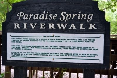
The Wabash River
Paradise Spring Riverwalk
The river was named Wah-Bah-Shi -Ka, meaning “water over the white rocks” by the Miami Indians. The French named it Quabache, from which the modern day name of Wabash is derived.
Created by the run-off from receding glaciers, the Wabash River is rich in history. It served as a major transportation route for Indians, explorers, canal barges and river boats.
Topics. This historical marker is listed in these topic lists: Colonial Era • Native Americans • Waterways & Vessels.
Location. 40° 47.706′ N, 85° 48.891′ W. Marker is in Wabash, Indiana, in Wabash County. Marker can be reached from S. Huntington Street south of E. Fulton Street. Marker is located in the southern part of Paradise Spring Park east of the parking lot; the above directions are to the park’s southwest parking lot. Touch for map. Marker is in this post office area: Wabash IN 46992, United States of America. Touch for directions.
Other nearby markers. At least 8 other markers are within walking distance of this marker. Paradise Spring Historical Park (about 300 feet away, measured in a direct line); Settler's Cabin (about 500 feet away); The Wabash River and the Big Four Cut (about 600 feet away); The Big Four Railroad (about 600 feet away); Kin-Com-A-Ong Spring (about 700 feet away); Storage Cabin (about 700 feet away); Cleveland, Cincinnati, Chicago & St. Louis Railway (about 700 feet away); Council House (about 800 feet away). Touch for a list and map of all markers in Wabash.
Credits. This page was last revised on June 16, 2016. It was originally submitted on August 26, 2014, by Duane Hall of Abilene, Texas. This page has been viewed 391 times since then and 14 times this year. Photos: 1, 2, 3. submitted on August 26, 2014, by Duane Hall of Abilene, Texas.


